
Woodford topographic map
Interactive map
Click on the map to display elevation.
Woodford
Woodford is a village in the Blue Mountains in New South Wales, Australia, about 90 kilometres west of the Sydney CBD. Its elevation is 609 metres (1,998 ft) above sea level. It is situated on the Great Western Highway and has a railway station (opened in 1868 as Buss's Platform) on the Main Western railway line served by NSW TrainLink's Blue Mountains services. At the 2016 census, Woodford had a population of 1,934.
About this map
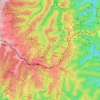
Name: Woodford topographic map, elevation, terrain.
Average elevation: 544 m
Minimum elevation: 360 m
Maximum elevation: 708 m
Other topographic maps
Click on a map to view its topography, its elevation and its terrain.
Prospect Hill
Australia > New South Wales > Sydney
As at 19 February 2001, the Prospect Hill area had state significance due to its unique combination of significant landscape feature, potential archaeological site, and association with important historical phases. As a dolerite outcrop rising to a height of 117 metres (384 ft) AHD , Prospect Hill is a rare…
Average elevation: 65 m
Sydney Observatory
Australia > New South Wales > Sydney
The place has an association with an extensive array of historical figures most of whom have helped shape its fabric. These include: colonial Governors Hunter, Bligh, Macquarie & Denison; military officers and engineers Macarthur; Barrallier; Bellasis and Minchin; convicts: the as yet unnamed constructors of…
Average elevation: 14 m