
Braga topographic map
Interactive map
Click on the map to display elevation.
About this map
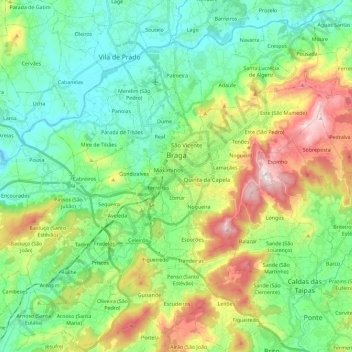
Name: Braga topographic map, elevation, terrain.
Location: Braga, Portugal (41.46373 -8.52609 41.61720 -8.29547)
Average elevation: 179 m
Minimum elevation: 7 m
Maximum elevation: 569 m
The topography in the municipality is characterized by irregular valleys, interspersed by mountainous spaces, fed by rivers running in parallel with the principal rivers. In the north it is limited by the Cávado River, in the south by terrain of the Serra dos Picos to a height of 566 metres (1,857 ft) and towards the east by the Serra dos Carvalhos to a height of 479 metres (1,572 ft), opening to the municipalities of Vila Nova de Famalicão and Barcelos. The territory extends from the northeast to southwest, accompanying the valleys of the two rivers, fed by many of its tributaries, forming small platforms between 20 metres (66 ft) and 570 metres (1,870 ft).
Other topographic maps
Click on a map to view its topography, its elevation and its terrain.
Facho
Portugal > Braga > Vila Nova de Famalicão
Facho, Vila Nova de Famalicão, Braga, 4760-484, Portugal
Average elevation: 151 m
Abade de Neiva
Abade de Neiva, Barcelos, Braga, Portugal
Average elevation: 109 m
Veade
Portugal > Braga > Celorico de Basto
Veade, Celorico de Basto, Braga, 4880-195, Portugal
Average elevation: 213 m
Vilela
Portugal > Braga > Póvoa de Lanhoso
Vilela, Póvoa de Lanhoso, Braga, Portugal
Average elevation: 186 m
Teixugueira
Portugal > Braga > Vieira do Minho > Louredo
Teixugueira, Louredo, Vieira do Minho, Braga, 4850-214, Portugal
Average elevation: 443 m
Louredo
Portugal > Braga > Vieira do Minho
Louredo, Vieira do Minho, Braga, Portugal
Average elevation: 504 m
Fonte do Milho
Portugal > Braga > Póvoa de Lanhoso > Garfe
Fonte do Milho, Garfe, Póvoa de Lanhoso, Braga, 4830-291, Portugal
Average elevation: 246 m
Santa Lucrécia de Algeriz e Navarra
Santa Lucrécia de Algeriz e Navarra, Braga, Portugal
Average elevation: 149 m
Travassos
Portugal > Braga > Póvoa de Lanhoso
Travassos, Póvoa de Lanhoso, Braga, Portugal
Average elevation: 332 m
Ribeirão
Portugal > Braga > Vila Nova de Famalicão
Ribeirão, Vila Nova de Famalicão, Braga, Portugal
Average elevation: 71 m
Pedras Alvas
Portugal > Braga > Celorico de Basto > Codeçoso
Pedras Alvas, Codeçoso, Celorico de Basto, Braga, 4890, Portugal
Average elevation: 329 m
Esqueiros, Nevogilde e Travassós
Portugal > Braga > Vila Verde
Esqueiros, Nevogilde e Travassós, Vila Verde, Braga, 4730-160, Portugal
Average elevation: 182 m
Souto (Santa Maria)
Souto (Santa Maria), Souto Santa Maria, Souto São Salvador e Gondomar, Guimarães, Braga, Portugal
Average elevation: 220 m
Vila Nova de Famalicão
Vila Nova de Famalicão, Braga, Portugal
Average elevation: 139 m
Santiago
Portugal > Braga > Vila de Prado
Santiago, Vila de Prado, Vila Verde, Braga, 4730-245, Portugal
Average elevation: 46 m
Mosteiro
Portugal > Braga > Vieira do Minho
Mosteiro, Vieira do Minho, Braga, Portugal
Average elevation: 436 m
Póvoa de Lanhoso
Portugal > Braga > Póvoa de Lanhoso
Póvoa de Lanhoso, Braga, Portugal
Average elevation: 256 m
Lapela
Portugal > Braga > Cabeceiras de Basto
Lapela, Cabeceiras de Basto, Braga, Portugal
Average elevation: 728 m