
Gadherni topographic map
Interactive map
Click on the map to display elevation.
About this map
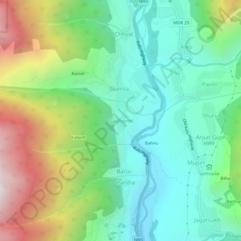
Name: Gadherni topographic map, elevation, terrain.
Location: Gadherni, Manali, Kullu, Himachal Pradesh, 175143, India (32.19615 77.16487 32.23615 77.20487)
Average elevation: 2,170 m
Minimum elevation: 1,692 m
Maximum elevation: 3,158 m
Other topographic maps
Click on a map to view its topography, its elevation and its terrain.
Kullu valley viewpoint
India > Himachal Pradesh > Manali > Manali
Kullu valley viewpoint, Mathiana to Sethan, Manali, Kullu District, Himachal Pradesh, 175131, India
Average elevation: 3,160 m
Hamtah
India > Himachal Pradesh > Manali > Parini
Hamtah, Parini, Manali, Kullu, Himachal Pradesh, 175143, India
Average elevation: 2,395 m
Vashisht
India > Himachal Pradesh > Manali > Vashisht
Vashisht, Manali, Kullu, Himachal Pradesh, 175 131, India
Average elevation: 2,407 m
Kulang
India > Himachal Pradesh > Manali
Kulang, Manali, Kullu District, Himachal Pradesh, 175103, India
Average elevation: 2,563 m
Shuru
India > Himachal Pradesh > Manali > Shuru
Shuru, Manali, Kullu, Himachal Pradesh, 175143, India
Average elevation: 2,139 m