
Tunis topographic map
Click on the map to display elevation.
Tunis
The city of Tunis is built on a hill slope down to the lake of Tunis. These hills contain places such as Notre-Dame de Tunis, Ras Tabia, La Rabta, La Kasbah, Montfleury, and La Manoubia with altitudes just above 50 metres (160 feet). The city is located at the crossroads of a narrow strip of land between Lake Tunis and Séjoumi. The isthmus between them is what geologists call the "Tunis dome", which includes hills of limestone and sediments. It forms a natural bridge and since ancient times several major roads linking to Egypt and elsewhere in Tunisia have branched out from it. The roads also connect with Carthage, emphasizing its political and economic importance not only in Tunisia but more widely in North Africa and the Mediterranean Sea in ancient times.
About this map
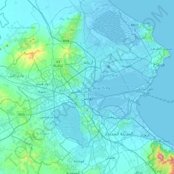
Name: Tunis topographic map, elevation, terrain.
Location: Tunis, Tunisia (36.69251 10.00379 36.94302 10.35481)
Average elevation: 37 m
Minimum elevation: -7 m
Maximum elevation: 542 m
Other topographic maps
Click on a map to view its topography, its elevation and its terrain.
Carthage
The elevation of the land at the promontory on the seashore to the north-east (now called Sidi Bou Saïd), was twice as high above sea level as that at the Byrsa (100 m and 50 m). In between runs a ridge, several times reaching 50 m; it continues northwestward along the seashore, and forms the edge of a…
Average elevation: 9 m
Medina of Tunis
In the case of domestic architecture, the more a building is set back from the shops, the more it is valued. The concept of withdrawal and privacy is paramount. The late introduction of a sewer system means that much waste water still flows through the streets of the Medina. The largest houses and noble places…
Average elevation: 16 m
Carthage
The elevation of the land at the promontory on the seashore to the north-east (now called Sidi Bou Saïd), was twice as high above sea level as that at the Byrsa (100 m and 50 m). In between runs a ridge, several times reaching 50 m; it continues northwestward along the seashore, and forms the edge of a…
Average elevation: 9 m