
Ingeldorf topographic map
Interactive map
Click on the map to display elevation.
About this map
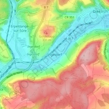
Name: Ingeldorf topographic map, elevation, terrain.
Location: Ingeldorf, Erpeldange-sur-Sûre, Canton Diekirch, 9161, Luxemburg (49.83324 6.11406 49.87324 6.15406)
Average elevation: 272 m
Minimum elevation: 190 m
Maximum elevation: 373 m
Other topographic maps
Click on a map to view its topography, its elevation and its terrain.
Buurschter-Millen
Luxemburg > Canton Diekirch > Lipperscheid
Buurschter-Millen, Lipperscheid, Bourscheid, Canton Diekirch, 9164, Luxemburg
Average elevation: 373 m
Herrenberg
Luxemburg > Canton Diekirch > Diekirch
Herrenberg, Diekirch, Canton Diekirch, 9220, Luxemburg
Average elevation: 266 m
Bourscheid
Luxemburg > Canton Diekirch > Bourscheid
Bourscheid, Canton Diekirch, Luxemburg
Average elevation: 381 m