
Make a donation
Gear up for your next adventure:
As an Amazon Associate, this site earns from qualifying purchases at no extra cost to you.
okres Praha-západ topographic map
Click on the map to display elevation.
Make a donation
Gear up for your next adventure:
As an Amazon Associate, this site earns from qualifying purchases at no extra cost to you.
okres Praha-západ
The territory of the district forms a half-moon surrounding Prague from the west. The elongated shape of the territory thus extends into different types of landscapes, in the north rather flat, in the south more rugged and hilly. It extends into five geomorphological mesoregions: Prague Plateau (north and east), Křivoklát Highlands (a small part in the west), Hořovice Uplands (an elongated part around the Berounka River), Brdy Highlands (elongated part south of the Berounka) and Benešov Uplands (south). The highest point of the district is the hill Lípový vrch in Libeř with an elevation of 458 m (1,503 ft), the lowest point is the river bed of the Vltava in Libčice nad Vltavou at 170 m (560 ft).
Make a donation
Gear up for your next adventure:
As an Amazon Associate, this site earns from qualifying purchases at no extra cost to you.
About this map
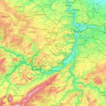
Name: okres Praha-západ topographic map, elevation, terrain.
Location: okres Praha-západ, Central Bohemia, Czechia (49.78294 14.11839 50.21395 14.57947)
Average elevation: 343 m
Minimum elevation: 171 m
Maximum elevation: 690 m
Make a donation
Gear up for your next adventure:
As an Amazon Associate, this site earns from qualifying purchases at no extra cost to you.
Other topographic maps
Click on a map to view its topography, its elevation and its terrain.
Make a donation
Gear up for your next adventure:
As an Amazon Associate, this site earns from qualifying purchases at no extra cost to you.
Make a donation
Gear up for your next adventure:
As an Amazon Associate, this site earns from qualifying purchases at no extra cost to you.