Geolocate

River topographic map

Click on the map to display elevation.

About this map

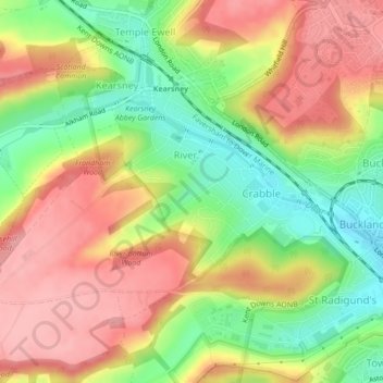
Name: River topographic map, elevation, terrain.

Location: River, Dover, Kent, England, United Kingdom (51.13301 1.25211 51.14895 1.28951)

Average elevation: 80 m

Minimum elevation: 15 m

Maximum elevation: 136 m

Kent trails, hiking, mountain biking, running and outdoor activities

Other topographic maps

Click on a map to view its topography, its elevation and its terrain.

River Stour

United Kingdom > England > Kent > Dover > Ash

Average elevation: 3 m

Green Lane Hill

United Kingdom > England > Kent > Dover > Whitfield

Average elevation: 93 m

Waldershare

United Kingdom > England > Kent > Dover > Tilmanstone

Average elevation: 89 m

Ringwould

United Kingdom > England > Kent > Dover

Average elevation: 45 m

Martin

United Kingdom > England > Kent > Dover

Average elevation: 70 m

Dover Castle

United Kingdom > England > Kent > Dover

Average elevation: 47 m

Elmstone

United Kingdom > England > Kent > Dover > Preston

Average elevation: 13 m

Wootton

United Kingdom > England > Kent > Dover

Average elevation: 119 m

Church Hougham

United Kingdom > England > Kent > Dover

Average elevation: 89 m

Kearsney

United Kingdom > England > Kent > Dover

Average elevation: 94 m

Ham

United Kingdom > England > Kent > Dover

Average elevation: 16 m

Shatterling

United Kingdom > England > Kent > Dover > Staple

Average elevation: 18 m

Sandwich Bay

United Kingdom > England > Kent > Dover

Average elevation: 1 m

Westmarsh

United Kingdom > England > Kent > Dover > Ash

Average elevation: 8 m

Hacklinge

United Kingdom > England > Kent > Dover > Worth

Average elevation: 10 m

Lower Eythorne

United Kingdom > England > Kent > Dover > Eythorne

Average elevation: 75 m

Wolverton

United Kingdom > England > Kent > Dover > Alkham > Wolverton

Average elevation: 108 m

South Alkham

United Kingdom > England > Kent > Dover > Alkham > South Alkham

Average elevation: 123 m

Coldred

United Kingdom > England > Kent > Dover > Shepherdswell > Coldred

Average elevation: 106 m

Barnsole

United Kingdom > England > Kent > Dover > Staple

Average elevation: 24 m

Richborough

United Kingdom > England > Kent > Dover

Average elevation: 4 m

Gear up for your next adventure:

👕Technical Hiking Tees - Moisture-management for high-exertion climbs
📱Phone Mounts for Hiking - Secure mounts to carry your phone on trails
🥼Base Layers - Thermal base layers for temperature regulation
🛰️Handheld GPS Devices - Reliable GPS units for hiking and outdoor navigation
🔦LED Camping Lanterns - Illumination for reading maps inside your tent at night

As an Amazon Associate, this site earns from qualifying purchases at no extra cost to you.