
Ham topographic map
Click on the map to display elevation.
About this map
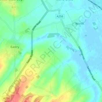
Name: Ham topographic map, elevation, terrain.
Location: Ham, Eastry, Dover, Kent, England, CT14 0EB, United Kingdom (51.22549 1.31025 51.26549 1.35025)
Average elevation: 16 m
Minimum elevation: -3 m
Maximum elevation: 60 m
Kent trails, hiking, mountain biking, running and outdoor activities
Other topographic maps
Click on a map to view its topography, its elevation and its terrain.
St Margaret's Bay
United Kingdom > England > Kent > Dover > St. Margaret's at Cliffe
Average elevation: 38 m
White Cliffs of Dover
United Kingdom > England > Kent > Dover > St. Margaret's at Cliffe
Average elevation: 49 m