
Make a donation
Gear up for your next adventure:
As an Amazon Associate, this site earns from qualifying purchases at no extra cost to you.
Miranda State topographic map
Click on the map to display elevation.
Make a donation
Gear up for your next adventure:
As an Amazon Associate, this site earns from qualifying purchases at no extra cost to you.
Miranda State
The hydrography of Miranda State is characterized by the short course and low flow of its rivers, with the exception of Tuy. This characteristic, combined with the settlement of the largest mass of population in the country, gives its rivers great significance as sources of water for urban consumption. The Tuy River, with a length of 250 km, rises at an altitude of 2 100 m, on the southern flank of the Litoral mountain range, flows eastwards through the Abra de Tácata to the Tuy and Barlovento valleys, and flows into the Caribbean Sea through the Paparo mouth. The El Jarillo River and the Aguas Frías and La Negra streams, tributaries of the Tuy on the left bank, have been dammed, near the Teques, in the Agua Fría reservoir, while the Ocumare, was dammed near Ocumare del Tuy, in the Ocumarito reservoir. The best known tributary is the Guaire River. On the right bank, the Tuy receives the Taguaza, Taguacita and Cuira rivers. Other important rivers are the Guarenas, Rio Grande or Caucagua, Capaya, El Guapo, Pacairigua, El Curiepe and Cúpira.
Make a donation
Gear up for your next adventure:
As an Amazon Associate, this site earns from qualifying purchases at no extra cost to you.
About this map
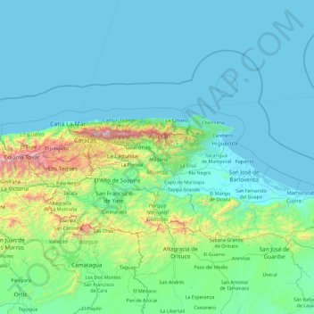
Name: Miranda State topographic map, elevation, terrain.
Location: Miranda State, Venezuela (9.93715 -67.24590 10.87641 -65.42090)
Average elevation: 255 m
Minimum elevation: 0 m
Maximum elevation: 2,666 m
Make a donation
Gear up for your next adventure:
As an Amazon Associate, this site earns from qualifying purchases at no extra cost to you.
Other topographic maps
Click on a map to view its topography, its elevation and its terrain.
Caracas
Venezuela > Capital District > Caracas
Cerro El Ávila (Mountain El Ávila) (Indigenous name: Waraira Repano), is a mountain in the mid-North of Venezuela. It rises next to Caracas and separates the city from the Caribbean Sea; The area's highest elevation is Pico Naiguatá, at 2,765 metres (9,072 ft) above sea level. It is considered the lungs of…
Average elevation: 858 m
Guiana Highlands
Venezuela > Bolivar State > Municipio Angostura
The Guiana Shield (French: Plateau des Guyanes, Bouclier guyanais; Dutch: Hoogland van Guyana, Guianaschild; Portuguese: Planalto das Guianas, Escudo das Guianas; Spanish: Escudo guayanés) is one of the three cratons of the South American Plate. It is a 1.7 billion-year-old Precambrian geological formation in…
Average elevation: 524 m
Make a donation
Gear up for your next adventure:
As an Amazon Associate, this site earns from qualifying purchases at no extra cost to you.
Make a donation
Gear up for your next adventure:
As an Amazon Associate, this site earns from qualifying purchases at no extra cost to you.
Archipiélago Los Hermanos
Venezuela > Federal Dependencies > Archipiélago Los Hermanos
Average elevation: 0 m
Make a donation
Gear up for your next adventure:
As an Amazon Associate, this site earns from qualifying purchases at no extra cost to you.
Topo La Florida
Venezuela > Aragua State > Municipio Santos Michelena > La Florida
Average elevation: 980 m
Make a donation
Gear up for your next adventure:
As an Amazon Associate, this site earns from qualifying purchases at no extra cost to you.
Make a donation
Gear up for your next adventure:
As an Amazon Associate, this site earns from qualifying purchases at no extra cost to you.
Make a donation
Gear up for your next adventure:
As an Amazon Associate, this site earns from qualifying purchases at no extra cost to you.
Make a donation
Gear up for your next adventure:
As an Amazon Associate, this site earns from qualifying purchases at no extra cost to you.
Parque Metropolitano Laguna de Las Peonías
Venezuela > Zulia State > Municipio Mara > Santa Cruz de Mara
Average elevation: 1 m
Make a donation
Gear up for your next adventure:
As an Amazon Associate, this site earns from qualifying purchases at no extra cost to you.
Make a donation
Gear up for your next adventure:
As an Amazon Associate, this site earns from qualifying purchases at no extra cost to you.
Make a donation
Gear up for your next adventure:
As an Amazon Associate, this site earns from qualifying purchases at no extra cost to you.
Make a donation
Gear up for your next adventure:
As an Amazon Associate, this site earns from qualifying purchases at no extra cost to you.
Make a donation
Gear up for your next adventure:
As an Amazon Associate, this site earns from qualifying purchases at no extra cost to you.
Make a donation
Gear up for your next adventure:
As an Amazon Associate, this site earns from qualifying purchases at no extra cost to you.
Make a donation
Gear up for your next adventure:
As an Amazon Associate, this site earns from qualifying purchases at no extra cost to you.
Mount Venamo
Venezuela > Bolivar State > Municipio Sifontes
A mountain in Guyana named Waukauyengtipu is often mistakenly synonymized with Mount Venamo, yet they are separate plateaus and each should be recognized by their respective, separate names. Most of the information about the true location and elevation of Cerro Venamo is taken from the results of Julian A.…
Average elevation: 1,293 m
Make a donation
Gear up for your next adventure:
As an Amazon Associate, this site earns from qualifying purchases at no extra cost to you.