
Make a donation
Gear up for your next adventure:
As an Amazon Associate, this site earns from qualifying purchases at no extra cost to you.
Zulia topographic map
Click on the map to display elevation.
Make a donation
Gear up for your next adventure:
As an Amazon Associate, this site earns from qualifying purchases at no extra cost to you.
About this map
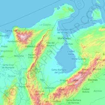
Name: Zulia topographic map, elevation, terrain.
Location: Zulia, Zuliana region, Venezuela (7.44376 -74.81912 12.64376 -69.61912)
Average elevation: 381 m
Minimum elevation: -5 m
Maximum elevation: 5,479 m
Make a donation
Gear up for your next adventure:
As an Amazon Associate, this site earns from qualifying purchases at no extra cost to you.
Other topographic maps
Click on a map to view its topography, its elevation and its terrain.
Make a donation
Gear up for your next adventure:
As an Amazon Associate, this site earns from qualifying purchases at no extra cost to you.
Coche Island
Venezuela > Nueva Esparta State > Municipio Villalba > El Bichar
It covers an area of 55 km2 (21 sq mi) (11 km (7 mi) long by 6 km (4 mi)), with a population of about 8,200 (1999 census). The highest elevation of the island is 60 metres (197 ft) above sea level. The climate is tropical, with an average temperature of approximately 27 to 38 °C (81 to 100 °F).
Average elevation: 6 m
Make a donation
Gear up for your next adventure:
As an Amazon Associate, this site earns from qualifying purchases at no extra cost to you.
Make a donation
Gear up for your next adventure:
As an Amazon Associate, this site earns from qualifying purchases at no extra cost to you.
Make a donation
Gear up for your next adventure:
As an Amazon Associate, this site earns from qualifying purchases at no extra cost to you.
Make a donation
Gear up for your next adventure:
As an Amazon Associate, this site earns from qualifying purchases at no extra cost to you.
Make a donation
Gear up for your next adventure:
As an Amazon Associate, this site earns from qualifying purchases at no extra cost to you.
Parroquia San Antonio de los Altos
Venezuela > Miranda State > Municipio Los Salias
San Antonio de los Altos is part of the Altos Mirandinos Metropolitan Area, which is, in itself part of the Metropolitan Region of Caracas. It covers an area of about 55 km2 (21 sq mi) and has an average altitude of 1,300 metres (4,300 ft) above sea level. San Antonio is the highest point in the Altos…
Average elevation: 1,240 m
Parque Metropolitano Laguna de Las Peonías
Venezuela > Zulia State > Municipio Mara > Santa Cruz de Mara
Average elevation: 1 m
Zaraza
Venezuela > Guarico State > Municipio Zaraza
Zaraza is located on the northeastern edge of the state of Guárico, on the crossroads of Troncal 13 and Troncal 14. Its average elevation is 52 meters above the sea level.
Average elevation: 52 m
Make a donation
Gear up for your next adventure:
As an Amazon Associate, this site earns from qualifying purchases at no extra cost to you.
Parroquia San Juan Bautista
Venezuela > Tachira State > Municipio San Cristóbal
Average elevation: 1,269 m
Laguna de Las Peonias
Venezuela > Zulia State > Municipio Mara > Santa Cruz de Mara
Average elevation: 3 m
Make a donation
Gear up for your next adventure:
As an Amazon Associate, this site earns from qualifying purchases at no extra cost to you.
Make a donation
Gear up for your next adventure:
As an Amazon Associate, this site earns from qualifying purchases at no extra cost to you.
Make a donation
Gear up for your next adventure:
As an Amazon Associate, this site earns from qualifying purchases at no extra cost to you.
Miranda State
The hydrography of Miranda State is characterized by the short course and low flow of its rivers, with the exception of Tuy. This characteristic, combined with the settlement of the largest mass of population in the country, gives its rivers great significance as sources of water for urban consumption. The Tuy…
Average elevation: 255 m
Maturin
Venezuela > Monagas State > Municipio Maturín
Maturin is located at 67 meters of altitude and 520 kilometres from the country's capital, Caracas. It is right next to the Guarapiche River and is a crossroad for roads towards the center, the Caribbean coast and the Orinoco River
Average elevation: 58 m
Make a donation
Gear up for your next adventure:
As an Amazon Associate, this site earns from qualifying purchases at no extra cost to you.
Parroquia Santos de Abelgas
Venezuela > Delta Amacuro State > Municipio Antonio Díaz
Average elevation: 6 m
Make a donation
Gear up for your next adventure:
As an Amazon Associate, this site earns from qualifying purchases at no extra cost to you.