
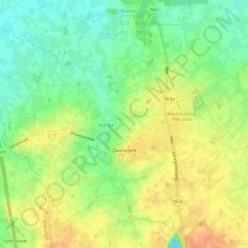
Zwevezele topographic map
Interactive map
Click on the map to display elevation.
About this map
Name: Zwevezele topographic map, elevation, terrain.
Average elevation: 30 m
Minimum elevation: 12 m
Maximum elevation: 50 m
Other topographic maps
Click on a map to view its topography, its elevation and its terrain.
Egem
Belgique > Flandre-Occidentale > Tielt
Egem, Pittem, Tielt, Flandre-Occidentale, Belgique
Average elevation: 34 m
Wingene
Belgique > Flandre-Occidentale > Tielt > Wingene
Wingene, Tielt, Flandre-Occidentale, Flandre, 8750, Belgique
Average elevation: 23 m
Dentergem
Belgique > Flandre-Occidentale > Tielt > Dentergem
Dentergem, Tielt, Flandre-Occidentale, Flandre, 8720, Belgique
Average elevation: 11 m
Tielt
Belgique > Flandre-Occidentale > Tielt > Tielt
Tielt, Flandre-Occidentale, 8700, Belgique
Average elevation: 24 m