
Valdez topographic map
Interactive map
Click on the map to display elevation.
About this map
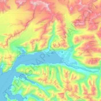
Name: Valdez topographic map, elevation, terrain.
Location: Valdez, Unorganized Borough, Alaska, 99686, United States (61.02246 -146.73145 61.25816 -145.83641)
Average elevation: 843 m
Minimum elevation: -3 m
Maximum elevation: 2,544 m
Other topographic maps
Click on a map to view its topography, its elevation and its terrain.
Glacier Bay
United States > Alaska > Unorganized Borough
Glacier Bay is covered with 1,375 square miles (3,560 km2) of glaciers which accounts for 27% of the Park area with most glaciers originating in mountains with elevation range of 8,000–15,000 feet (2,400–4,600 m). There are over 50 named glaciers (both tidewater and terrestrial glaciers); 10 tide water…
Average elevation: 402 m
Lituya Bay
United States > Alaska > Unorganized Borough
The same topography that leads to the heavy tidal currents also created the tsunami with the highest runup against a hillside in recorded history. On the night of July 9, 1958, an earthquake caused a landslide in the Gilbert Inlet at the head of the bay, generating a massive megatsunami which had sufficient…
Average elevation: 217 m
Kiska Island
United States > Alaska > Unorganized Borough
Renamed "Skira", the island was used as the setting for the Codemasters video game Operation Flashpoint: Dragon Rising. The fictionalized version of the island is relocated closer to Russia and China, but the island's topography is replicated near-exactly, with elements of the game designed around it, instead…
Average elevation: 40 m
Eagle Summit
United States > Alaska > Unorganized Borough
It was for this latter reason that engineers chose Eagle Summit as the route to build the Steese Highway, which connects Fairbanks, Alaska to the Yukon River at Circle. In 1927, just 11 years after Stuck became one of the first Americans to navigate Eagle Summit on dog sled, the highway was completed and road…
Average elevation: 1,068 m
Nikolai
United States > Alaska > Unorganized Borough
Farewell Lake is a weather station roughly 38 miles south of Nikolai, at an elevation of 1060 ft (323.1 m). Farewell Lake has a subarctic climate (Köppen Dfc).
Average elevation: 132 m
Glacier Bay
United States > Alaska > Unorganized Borough
Glacier Bay is covered with 1,375 square miles (3,560 km2) of glaciers which accounts for 27% of the Park area with most glaciers originating in mountains with elevation range of 8,000–15,000 feet (2,400–4,600 m). There are over 50 named glaciers (both tidewater and terrestrial glaciers); 10 tide water…
Average elevation: 402 m
Saint Paul Island
United States > Alaska > Unorganized Borough > St. Paul
Saint Paul is the largest of the Pribilof Islands and lies the farthest north. With a width of 7.66 mi (12.33 km) at its widest point and a length of 13.5 mi (21.7 km) on its longest axis (which runs from northeast to southwest), it has a total area of 43 sq mi (110 km2). Volcanic in origin, Saint Paul…
Average elevation: 10 m
Annette Island
United States > Alaska > Unorganized Borough
The lower elevations of Annette Island have a Marine west coast climate (Köppen Cfb), with windy and wet weather year-round, cool winters, and mild summers, and straddle the border between USDA Plant Hardiness Zones 7 and 8. Due to its southerly and maritime location, with an annual mean temperature of 47.7…
Average elevation: 78 m
Lituya Bay
United States > Alaska > Unorganized Borough
The same topography that leads to the heavy tidal currents also created the tsunami with the highest runup against a hillside in recorded history. On the night of July 9, 1958, an earthquake caused a landslide in the Gilbert Inlet at the head of the bay, generating a massive megatsunami which had sufficient…
Average elevation: 217 m