
銅門村 topographic map
Interactive map
Click on the map to display elevation.
About this map
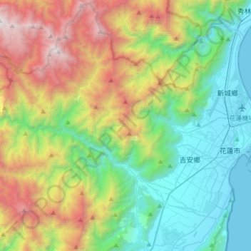
Name: 銅門村 topographic map, elevation, terrain.
Location: 銅門村, 秀林鄉, 花蓮縣, 臺灣 (23.91397 121.25994 24.09834 121.53136)
Average elevation: 1,076 m
Minimum elevation: -3 m
Maximum elevation: 3,326 m
銅門村(太魯閣語:Dowmung),臺灣一個原住民村落,位於木瓜溪中、上游,是花蓮縣秀林鄉轄下的行政區劃,為太魯閣族所居住。由於四周環山,全村海拔可從約300公尺,一直爬升至1,200公尺,並以木瓜溪的景色為之秀麗。
Other topographic maps
Click on a map to view its topography, its elevation and its terrain.