
Make a donation
Gear up for your next adventure:
As an Amazon Associate, this site earns from qualifying purchases at no extra cost to you.
Seungbong-ri topographic map
Click on the map to display elevation.
Make a donation
Gear up for your next adventure:
As an Amazon Associate, this site earns from qualifying purchases at no extra cost to you.
About this map
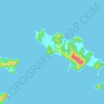
Name: Seungbong-ri topographic map, elevation, terrain.
Location: Seungbong-ri, Incheon, South Korea (37.14612 126.27868 37.18612 126.31868)
Average elevation: 4 m
Minimum elevation: 0 m
Maximum elevation: 90 m
Make a donation
Gear up for your next adventure:
As an Amazon Associate, this site earns from qualifying purchases at no extra cost to you.
Other topographic maps
Click on a map to view its topography, its elevation and its terrain.
Dong-gu
The city area is developed on a hill with an elevation of 30–40 m above sea level, and the reclaimed land on the north coast is formed as a seashore industrial complex, forming a part of the Incheon seashore industrial zone and connected to the Juan and Bupyeong industrial complexes. Although the population…
Average elevation: 15 m
Make a donation
Gear up for your next adventure:
As an Amazon Associate, this site earns from qualifying purchases at no extra cost to you.
Make a donation
Gear up for your next adventure:
As an Amazon Associate, this site earns from qualifying purchases at no extra cost to you.
Make a donation
Gear up for your next adventure:
As an Amazon Associate, this site earns from qualifying purchases at no extra cost to you.