
Osasco topographic map
Interactive map
Click on the map to display elevation.
Osasco
Is an average elevation of 792 meters and 65 km2 of area. Its boundaries are São Paulo to the north, east and south, Cotia to the southwest, Carapicuíba and Barueri to the west and Santana de Parnaíba to the northwest.
About this map
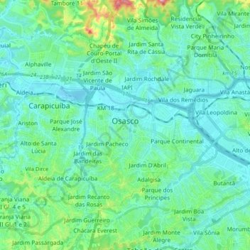
Name: Osasco topographic map, elevation, terrain.
Average elevation: 768 m
Minimum elevation: 714 m
Maximum elevation: 1,040 m
Other topographic maps
Click on a map to view its topography, its elevation and its terrain.
São Paulo
Brazil > São Paulo > Região Metropolitana de São Paulo
The city is on a plateau placed beyond the Serra do Mar (Portuguese for "Sea Range" or "Coastal Range"), itself a component of the vast region known as the Brazilian Highlands, with an average elevation of around 799 meters (2,621 ft) above sea level, although being at a distance of only about 70 kilometers…
Average elevation: 716 m
São Paulo
Brazil > São Paulo > Região Metropolitana de São Paulo > São Paulo
São Paulo is in Southeastern Brazil, in southeastern São Paulo State, approximately halfway between Curitiba and Rio de Janeiro. The city is on a plateau placed beyond the Serra do Mar (Portuguese for "Sea Range" or "Coastal Range"), itself a component of the vast region known as the Brazilian Highlands,…
Average elevation: 785 m
Itapecerica da Serra
Brazil > São Paulo > Região Metropolitana de São Paulo
Itapecerica da Serra (Portuguese pronunciation: [itapeˈsɛɾikɐ dɐ ˈsɛʁɐ]) is a municipality in the Brazilian state of São Paulo. It is part of the Metropolitan Region of São Paulo. The population is 177,662 (2020 est.) in an area of 150.74 km2 (58.20 sq mi). It is located 23 miles southwest of São…
Average elevation: 819 m
Paranapiacaba
Brazil > São Paulo > Região Metropolitana de São Paulo > Santo André
Average elevation: 650 m
José Bonifácio
Brazil > São Paulo > Região Metropolitana de São Paulo > São Paulo
Average elevation: 793 m
Embu-Guaçu
Brazil > São Paulo > Região Metropolitana de São Paulo
Embu-Guaçu is a municipality in the state of São Paulo in Brazil. It is part of the Metropolitan Region of São Paulo. The population is 69,901 (2020 est.) in an area of 155.64 km². The elevation is 408 m.
Average elevation: 789 m
Ferraz de Vasconcelos
Brazil > São Paulo > Região Metropolitana de São Paulo
Ferraz de Vasconcelos is situated in the eastern region of Greater São Paulo. Altitude: 759 meters above sea level. Limits are Poa and Suzano east, São Paulo west, Mauá southwest Ribeirão Pires and south Itaquaquecetuba north .
Average elevation: 791 m
Itaim Paulista
Brazil > São Paulo > Região Metropolitana de São Paulo > São Paulo
Average elevation: 762 m
Taiaçupeba
Brazil > São Paulo > Região Metropolitana de São Paulo > Mogi das Cruzes
Average elevation: 808 m
São Bernardo do Campo
Brazil > São Paulo > Região Metropolitana de São Paulo > São Bernardo do Campo
Average elevation: 760 m
Itapevi
Brazil > São Paulo > Região Metropolitana de São Paulo
In 1912, Joaquim Nunes Filho (Nho Quim), from Cotia city, purchased the Sítio Itapevy, with 152 bushels. This place covering all the current city center. Nunes became a local political boss, for his ties to the former PRP (Partido Republicano Paulista). He managed the elevation of the village to district…
Average elevation: 814 m
Cotia
Brazil > São Paulo > Região Metropolitana de São Paulo
Cotia is a municipality in the state of São Paulo in Brazil. It is part of the Metropolitan Region of São Paulo. The population is 253,608 (2020 est.) in an area of 323.99 km2. The city is at an elevation of 853 m. Cotia is linked with the Rodovia Raposo Tavares highway.
Average elevation: 859 m
Região Imediata de São Paulo
Brazil > São Paulo > Região Metropolitana de São Paulo
Average elevation: 547 m
Santo André
Brazil > São Paulo > Região Metropolitana de São Paulo > Santo André
Average elevation: 776 m
Santa Isabel
Brazil > São Paulo > Região Metropolitana de São Paulo
Santa Isabel (Portuguese pronunciation: [ˈsɐ̃tɐ jzɐˈbɛw]) is a municipality in the state of São Paulo in Brazil. It is part of the Metropolitan Region of São Paulo. The population is 57,966 (2020 est.) in an area of 363.33 km². The elevation is 655 m. It is located 60 miles east of the downtown of…
Average elevation: 730 m
Itaquaquecetuba
Brazil > São Paulo > Região Metropolitana de São Paulo > Itaquaquecetuba
Itaquaquecetuba is a municipality in the state of São Paulo, Brazil. It is part of the Metropolitan Region of São Paulo. The population is 352,801 (2015 est.) in an area of 82.62 square kilometres (31.90 sq mi). It sits at an elevation of 790 metres (2,592 ft).
Average elevation: 764 m
Mairiporã
Brazil > São Paulo > Região Metropolitana de São Paulo
Mairiporã is situated at an average altitude of 790m. The highest points of Mairiporã are in Serra da Cantareira, where it reaches an altitude of over 1100m in some areas.
Average elevation: 888 m