
Make a donation
Gear up for your next adventure:
As an Amazon Associate, this site earns from qualifying purchases at no extra cost to you.
Wokha topographic map
Click on the map to display elevation.
Make a donation
Gear up for your next adventure:
As an Amazon Associate, this site earns from qualifying purchases at no extra cost to you.
About this map
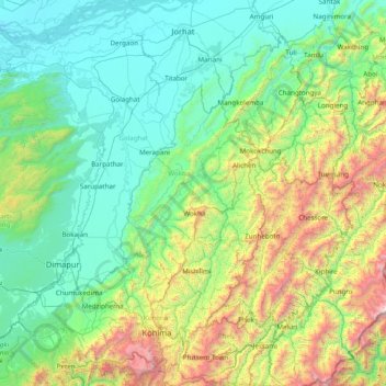
Name: Wokha topographic map, elevation, terrain.
Location: Wokha, Nagaland, India (25.46667 93.55000 26.86667 94.95000)
Average elevation: 719 m
Minimum elevation: 66 m
Maximum elevation: 3,590 m
Make a donation
Gear up for your next adventure:
As an Amazon Associate, this site earns from qualifying purchases at no extra cost to you.
Other topographic maps
Click on a map to view its topography, its elevation and its terrain.
Wokha
It covers an area of 1,628 sq. km. which equals around 9.82% of the total area of Nagaland. Of the total area, 35.74% comes under subtropical hill zone, 23.64% under subtropical plain zone and 40.59% in the mild tropical hill zone. The average altitude of the Wokha (Upper Range) is 1000-1500m above sea level;…
Average elevation: 466 m
Make a donation
Gear up for your next adventure:
As an Amazon Associate, this site earns from qualifying purchases at no extra cost to you.
Make a donation
Gear up for your next adventure:
As an Amazon Associate, this site earns from qualifying purchases at no extra cost to you.
Make a donation
Gear up for your next adventure:
As an Amazon Associate, this site earns from qualifying purchases at no extra cost to you.