
Make a donation
Gear up for your next adventure:
As an Amazon Associate, this site earns from qualifying purchases at no extra cost to you.
Ralan topographic map
Click on the map to display elevation.
Make a donation
Gear up for your next adventure:
As an Amazon Associate, this site earns from qualifying purchases at no extra cost to you.
About this map
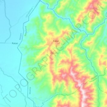
Name: Ralan topographic map, elevation, terrain.
Location: Ralan, Wokha, Nagaland, India (25.92158 93.95298 26.06856 94.07749)
Average elevation: 383 m
Minimum elevation: 128 m
Maximum elevation: 1,100 m
Make a donation
Gear up for your next adventure:
As an Amazon Associate, this site earns from qualifying purchases at no extra cost to you.
Other topographic maps
Click on a map to view its topography, its elevation and its terrain.
Make a donation
Gear up for your next adventure:
As an Amazon Associate, this site earns from qualifying purchases at no extra cost to you.
Kohima
India > Nagaland > Kohima Sadar
Kohima district is the land of the Angami Naga and Rengma Naga tribe. It is situated in the foothills of Japfu range located south of Kohima District (25°40′N 94°07′E / 25.67°N 94.12°E / 25.67; 94.12) and has an average elevation of 1,261 metres (4137 feet).
Average elevation: 1,425 m
Mokokchung
India > Nagaland > ONGPANGKONG (N)
Mokokchung is located at 26°20′N 94°32′E / 26.33°N 94.53°E / 26.33; 94.53. It is located at an elevation of 1325 metres above sea level.
Average elevation: 1,027 m
Make a donation
Gear up for your next adventure:
As an Amazon Associate, this site earns from qualifying purchases at no extra cost to you.
Make a donation
Gear up for your next adventure:
As an Amazon Associate, this site earns from qualifying purchases at no extra cost to you.