
Đồng Hới topographic map
Interactive map
Click on the map to display elevation.
About this map
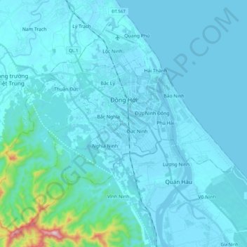
Name: Đồng Hới topographic map, elevation, terrain.
Location: Đồng Hới, Quang Binh province, Vietnam (17.36566 106.49234 17.53000 106.68640)
Average elevation: 45 m
Minimum elevation: -2 m
Maximum elevation: 683 m
The city has diverse topographical and geological features, including hill, mountainous, half mountainous, coastal plains and coastal sand dunes.
Other topographic maps
Click on a map to view its topography, its elevation and its terrain.
Gia Ninh
Vietnam > Quang Binh province > Quảng Ninh District
Gia Ninh, Quảng Ninh District, Quảng Bình Province, Vietnam
Average elevation: 9 m
Sơn Lý
Vietnam > Quang Binh province > Bố Trạch District
Sơn Lý, Bố Trạch District, Quang Binh province, Vietnam
Average elevation: 34 m
Phong Nha-Kẻ Bàng National Park
Phong Nha-Kẻ Bàng National Park, Quang Binh province, Vietnam
Average elevation: 424 m
Son Doong Cave
Vietnam > Quang Binh province > Bố Trạch
Son Doong Cave, West Ho Chi Minh Highway, Bố Trạch, Quang Binh province, Vietnam
Average elevation: 487 m
Lệ Thủy District
Lệ Thủy District, Quang Binh province, Vietnam
Average elevation: 171 m
Quảng Ninh District
Quảng Ninh District, Quang Binh province, Vietnam
Average elevation: 308 m
Kiến Giang
Vietnam > Quang Binh province > Lệ Thủy District > Kiến Giang
Kiến Giang, Lệ Thủy District, Quang Binh province, Vietnam
Average elevation: 3 m
Bố Trạch District
Bố Trạch District, Quảng Bình Province, Vietnam
Average elevation: 356 m
Phong Nha Town
Vietnam > Quang Binh province > Bố Trạch District
Phong Nha Town, Bố Trạch District, Quảng Bình Province, Vietnam
Average elevation: 66 m