
Swift County topographic map
Click on the map to display elevation.
Swift County
Swift County is primarily agricultural, but also hosts agriculture equipment manufacturers and an ethanol plant. It has 24 lakes and nine rivers and streams. Lake Oliver is one of the county's biggest, at 416 acres (1.7 km2). Caltopo shows the true highpoint to be 1300 ft in elevation about 1/3 of a mile southwest of the Monson State Wildlife Management Area:latitude 45.3046&longitude=-95.3031
About this map
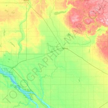
Name: Swift County topographic map, elevation, terrain.
Location: Swift County, Minnesota, United States (45.15130 -96.11850 45.41326 -95.24632)
Average elevation: 332 m
Minimum elevation: 282 m
Maximum elevation: 430 m
Other topographic maps
Click on a map to view its topography, its elevation and its terrain.
Eagle Mountain
United States > Minnesota > Cook County > West Cook
Eagle Mountain is only about 12 miles (19 km) from Minnesota's lowest elevation, Lake Superior, at 600 feet (183 m). It is part of the Canadian Shield. There is also another much shorter peak also named Eagle Mountain in northern Minnesota. The shorter peak is part of the Lutsen Mountains ski resort.
Average elevation: 596 m
Ancient River Warren Channel (historical)
United States > Minnesota > Traverse County
Average elevation: 300 m
Chris Lake
United States > Minnesota > Saint Louis County > Pequaywan Township
Average elevation: 494 m
Pearl Lake
United States > Minnesota > Stearns County > Maine Prairie Township
Average elevation: 343 m
Elm Creek Park (Maple Grove Arboretum)
United States > Minnesota > Hennepin County > Maple Grove
Average elevation: 278 m
Embarrass
United States > Minnesota > Saint Louis County > Embarrass Township
Average elevation: 438 m
Grey Cloud Island
United States > Minnesota > Washington County > Grey Cloud Island Township
Average elevation: 225 m
Riverbend Estates
United States > Minnesota > Nicollet County > North Mankato
Average elevation: 265 m
St. Croix River Boom Site Landing
United States > Minnesota > Washington County > Stillwater Township
Average elevation: 253 m
Middle Cullen Lake
United States > Minnesota > Crow Wing County > Pequot Lakes
Average elevation: 372 m
Spencer Lake
United States > Minnesota > Meeker County > Collinwood Township > Jennie
Average elevation: 334 m
Pond-Dakota Mission Park
United States > Minnesota > Hennepin County > Bloomington
Average elevation: 235 m
Tower Junction
United States > Minnesota > Saint Louis County > Breitung Township > Soudan
Average elevation: 437 m
Norway Creek
United States > Minnesota > Saint Louis County > Northeast St Louis
Average elevation: 424 m
Burnsville
United States > Minnesota > Dakota County > Burnsville > Burnsville
Average elevation: 275 m
Mississippi River
United States > Minnesota > Hennepin County > Minneapolis
The uppermost lock and dam on the Upper Mississippi River is the Upper St. Anthony Falls Lock and Dam in Minneapolis. Above the dam, the river's elevation is 799 feet (244 m). Below the dam, the river's elevation is 750 feet (230 m). This 49-foot (15 m) drop is the largest of all the Mississippi River locks…
Average elevation: 256 m
Suburban Mobile Home Park
United States > Minnesota > Morrison County > Little Falls
Average elevation: 349 m
Norway Lake
United States > Minnesota > Kandiyohi County > Arctander Township
Average elevation: 371 m
Eden Prairie
United States > Minnesota > Hennepin County > Eden Prairie > Eden Prairie
Average elevation: 267 m
Rum River North County Park
United States > Minnesota > Anoka County > Saint Francis
Average elevation: 279 m
Sungold Heights Mobile Home Park
United States > Minnesota > Nobles County > Worthington
Average elevation: 482 m
Central Lakes
United States > Minnesota > Saint Louis County > Ellsburg Township
Average elevation: 408 m
Echo River
United States > Minnesota > Saint Louis County > Northeast St Louis
Average elevation: 393 m
Moody Lake
United States > Minnesota > Chisago County > Chisago Lake Township
Average elevation: 283 m
Minnehaha Falls
United States > Minnesota > Hennepin County > Minneapolis
Fortunately for the generations to come, in 1883 the state legislature created the Minneapolis Board of Park Commissioners. The board began by acquiring park land near today's downtown Minneapolis. Their choice to hire noted landscape architect Horace Cleveland was fortunate. Cleveland was hired by the Board…
Average elevation: 249 m