
Brecht topographic map
Interactive map
Click on the map to display elevation.
About this map
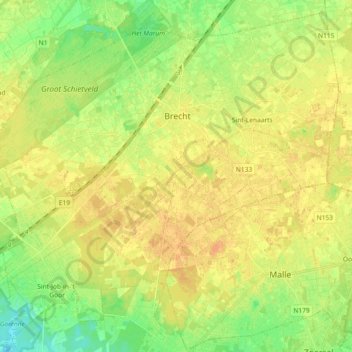
Name: Brecht topographic map, elevation, terrain.
Location: Brecht, Antwerp, Flanders, 2960, Belgium (51.27563 4.54078 51.38235 4.72359)
Average elevation: 22 m
Minimum elevation: 7 m
Maximum elevation: 32 m
Other topographic maps
Click on a map to view its topography, its elevation and its terrain.
Borgerhout
Belgium > Antwerp > Antwerp > Antwerp
Borgerhout, Antwerp, Flanders, 2140, Belgium
Average elevation: 8 m
Aartselaar
Aartselaar, Antwerp, Flanders, 2630, Belgium
Average elevation: 15 m
Brasschaat
Brasschaat, Antwerp, Flanders, 2930, Belgium
Average elevation: 14 m
Sint-Lenaarts
Belgium > Antwerp > Antwerp > Brecht
Sint-Lenaarts, Brecht, Antwerp, Flanders, Belgium
Average elevation: 24 m
Koornbloem
Belgium > Antwerp > Antwerp > Wilrijk > Koornbloem
Koornbloem, Wilrijk, Antwerp, Flanders, 2610, Belgium
Average elevation: 14 m