
Saint Patrick topographic map
Interactive map
Click on the map to display elevation.
About this map
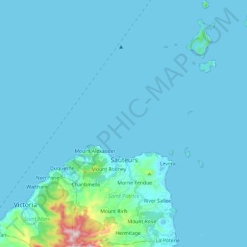
Name: Saint Patrick topographic map, elevation, terrain.
Location: Saint Patrick, Grenada (12.16724 -61.68297 12.33090 -61.54377)
Average elevation: 36 m
Minimum elevation: 0 m
Maximum elevation: 655 m
Other topographic maps
Click on a map to view its topography, its elevation and its terrain.
Carriacou
Grenada > Carriacou and Petite Martinique > Hillsborough
Carriacou, Hillsborough, Carriacou and Petite Martinique, Grenada
Average elevation: 18 m
Saint Patrick
Grenada > Saint Patrick > Snell Hall
Saint Patrick, Snell Hall, Saint Patrick, Grenada
Average elevation: 82 m
Industry
Grenada > Saint Patrick > Duquesne
Industry, Duquesne, Saint Patrick, Grenada
Average elevation: 72 m
Mt. Airy
Grenada > Saint David > Perdmontemps
Mt. Airy, Perdmontemps, Saint David, 1473, Grenada
Average elevation: 196 m