
Milton Ernest topographic map
Interactive map
Click on the map to display elevation.
About this map
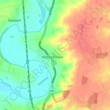
Name: Milton Ernest topographic map, elevation, terrain.
Location: Milton Ernest, Bedford, England, United Kingdom (52.18241 -0.53985 52.20544 -0.47854)
Average elevation: 61 m
Minimum elevation: 32 m
Maximum elevation: 94 m
Other topographic maps
Click on a map to view its topography, its elevation and its terrain.
Bedford
United Kingdom > England > Bedford
Bedford, England, MK40 1SU, United Kingdom
Average elevation: 37 m
Wootton Green
United Kingdom > England > Bedford > Wootton
Wootton Green, Wootton, Bedford, England, MK43 9EA, United Kingdom
Average elevation: 48 m
Little Wootton
United Kingdom > England > Bedford > Wootton
Little Wootton, Wootton, Bedford, England, MK43 9PY, United Kingdom
Average elevation: 52 m
Church End
United Kingdom > England > Bedford > Ravensden
Church End, Ravensden, Bedford, England, MK44 2RW, United Kingdom
Average elevation: 58 m
Rootham's Green
United Kingdom > England > Bedford
Rootham's Green, Colmworth, Bedford, England, MK44 2NJ, United Kingdom
Average elevation: 65 m
Box End
United Kingdom > England > Bedford
Box End, Kempston Rural, Bedford, England, MK43 8RS, United Kingdom
Average elevation: 43 m
Knotting
United Kingdom > England > Bedford
Knotting, Bedford, England, MK44 1AE, United Kingdom
Average elevation: 88 m
Kempston
United Kingdom > England > Bedford
Kempston, Bedford, England, United Kingdom
Average elevation: 33 m
Felmersham
United Kingdom > England > Bedford
Felmersham, Bedford, England, United Kingdom
Average elevation: 57 m
Turvey
United Kingdom > England > Bedford
Turvey, Bedford, England, United Kingdom
Average elevation: 73 m
Ravensden
United Kingdom > England > Bedford
Ravensden, Bedford, England, United Kingdom
Average elevation: 60 m
Wilden
United Kingdom > England > Bedford
Wilden, Bedford, England, United Kingdom
Average elevation: 59 m
Carlton and Chellington
United Kingdom > England > Bedford
Carlton and Chellington, Bedford, England, United Kingdom
Average elevation: 63 m
Stevington
United Kingdom > England > Bedford
Stevington, Bedford, England, United Kingdom
Average elevation: 58 m
Bolnhurst and Keysoe
United Kingdom > England > Bedford
Bolnhurst and Keysoe, Bedford, England, United Kingdom
Average elevation: 64 m
Odell
United Kingdom > England > Bedford
Odell, Bedford, England, United Kingdom
Average elevation: 76 m
Melchbourne and Yielden
United Kingdom > England > Bedford
Melchbourne and Yielden, Bedford, England, United Kingdom
Average elevation: 76 m
Little Staughton
United Kingdom > England > Bedford
Little Staughton, Bedford, England, United Kingdom
Average elevation: 58 m
Podington
United Kingdom > England > Bedford
Podington, Bedford, England, United Kingdom
Average elevation: 90 m
Elstow
United Kingdom > England > Bedford
Elstow, Bedford, England, United Kingdom
Average elevation: 32 m
Wilshamstead
United Kingdom > England > Bedford
Wilshamstead, Bedford, England, United Kingdom
Average elevation: 44 m
Bletsoe
United Kingdom > England > Bedford
Bletsoe, Bedford, England, United Kingdom
Average elevation: 71 m
Knotting and Souldrop
United Kingdom > England > Bedford
Knotting and Souldrop, Bedford, England, United Kingdom
Average elevation: 85 m
Pavenham
United Kingdom > England > Bedford
Pavenham, Bedford, England, United Kingdom
Average elevation: 57 m
Dean and Shelton
United Kingdom > England > Bedford
Dean and Shelton, Bedford, England, United Kingdom
Average elevation: 64 m
Shortstown
United Kingdom > England > Bedford
Shortstown, Bedford, England, United Kingdom
Average elevation: 30 m
Stewartby
United Kingdom > England > Bedford
Stewartby, Bedford, England, United Kingdom
Average elevation: 41 m
Little Barford
United Kingdom > England > Bedford > Little Barford
Little Barford, Bedford, England, United Kingdom
Average elevation: 26 m
Carlton
United Kingdom > England > Bedford > Carlton
Carlton, Bedford, East of England, England, MK43 7JR, United Kingdom
Average elevation: 62 m
Roxton
United Kingdom > England > Bedford
Roxton, Bedford, England, United Kingdom
Average elevation: 24 m
Staploe
United Kingdom > England > Bedford
Staploe, Bedford, England, United Kingdom
Average elevation: 35 m
Souldrop
United Kingdom > England > Bedford
Souldrop, Bedford, England, MK44 1HA, United Kingdom
Average elevation: 89 m
Renhold
United Kingdom > England > Bedford
Renhold, Bedford, England, United Kingdom
Average elevation: 41 m
Sharnbrook
United Kingdom > England > Bedford
Sharnbrook, Bedford, England, United Kingdom
Average elevation: 68 m
Cotton End
United Kingdom > England > Bedford
Cotton End, Bedford, England, United Kingdom
Average elevation: 44 m
Bromham
United Kingdom > England > Bedford
Bromham, Bedford, England, United Kingdom
Average elevation: 50 m
Oakley
United Kingdom > England > Bedford
Oakley, Bedford, England, United Kingdom
Average elevation: 49 m
Old Warden Tunnel
United Kingdom > England > Bedford > Cardington
Old Warden Tunnel, Southill Road, Cardington, Bedford, East of England, England, MK44 3TA, United Kingdom
Average elevation: 61 m
Pertenhall
United Kingdom > England > Bedford > Pertenhall
Pertenhall, Bedford, England, United Kingdom
Average elevation: 44 m
Wootton
United Kingdom > England > Bedford
Wootton, Bedford, England, United Kingdom
Average elevation: 46 m
Thurleigh
United Kingdom > England > Bedford
Thurleigh, Bedford, England, United Kingdom
Average elevation: 78 m
Colmworth
United Kingdom > England > Bedford
Colmworth, Bedford, East of England, England, United Kingdom
Average elevation: 63 m
Swineshead
United Kingdom > England > Bedford
Swineshead, Bedford, England, United Kingdom
Average elevation: 60 m
Willington
United Kingdom > England > Bedford
Willington, Bedford, England, United Kingdom
Average elevation: 30 m
Wymington
United Kingdom > England > Bedford
Wymington, Bedford, England, United Kingdom
Average elevation: 86 m
Cople
United Kingdom > England > Bedford
Cople, Bedford, England, United Kingdom
Average elevation: 31 m
Great Barford
United Kingdom > England > Bedford
Great Barford, Bedford, England, United Kingdom
Average elevation: 31 m
Cardington
United Kingdom > England > Bedford
Cardington, Bedford, England, United Kingdom
Average elevation: 34 m
Clapham
United Kingdom > England > Bedford
Clapham, Bedford, England, United Kingdom
Average elevation: 60 m
Stagsden
United Kingdom > England > Bedford
Stagsden, Bedford, England, United Kingdom
Average elevation: 69 m