
Hezhou topographic map
Interactive map
Click on the map to display elevation.
Hezhou
Hezhou is located in northeastern Guangxi. It borders Hunan to the north and Guangdong to the east. The area is 11,854 km2 (4,577 sq mi). The average elevation is 800 m (2,600 ft) and the highest is 1,731 m (5,679 ft) above sea-level.
About this map
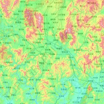
Name: Hezhou topographic map, elevation, terrain.
Location: Hezhou, Guangxi, China (23.65462 110.56709 25.15417 112.05641)
Average elevation: 393 m
Minimum elevation: 15 m
Maximum elevation: 1,756 m
Other topographic maps
Click on a map to view its topography, its elevation and its terrain.
Hechi
Hechi is located in northwestern Guangxi on the southern end of the Yunnan-Guizhou Plateau. The total area is 33,500 km2 (12,900 sq mi), with elevations increasing from southeast to northwest. It is very mountainous with ranges including in the north the Jiuwanda Mountains, in the northwest the Phoenix…
Average elevation: 257 m