
Mome topographic map
Interactive map
Click on the map to display elevation.
About this map
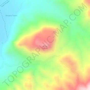
Name: Mome topographic map, elevation, terrain.
Location: Mome, Amaro Special Woreda, RNNPS, Éthiopie (5.88408 37.70327 5.88418 37.70337)
Average elevation: 1,341 m
Minimum elevation: 1,108 m
Maximum elevation: 1,673 m
Other topographic maps
Click on a map to view its topography, its elevation and its terrain.
Nechisar National Park Hq
Éthiopie > RNNPS > አርባ ምንጭ / Arba Minch
Nechisar National Park Hq, አርባ ምንጭ / Arba Minch, Gamo Gofa, RNNPS, 40, Éthiopie
Average elevation: 1,216 m
Tosa Sucha
Éthiopie > RNNPS > አርባ ምንጭ / Arba Minch
Tosa Sucha, አርባ ምንጭ / Arba Minch, Gamo Gofa, RNNPS, Éthiopie
Average elevation: 1,376 m
Gughe
Éthiopie > RNNPS > አርባ ምንጭ / Arba Minch
Gughe, አርባ ምንጭ / Arba Minch, Gamo Gofa, RNNPS, Éthiopie
Average elevation: 2,701 m
Butajiri-Silti Field
Butajiri-Silti Field, Guraghe, RNNPS, Éthiopie
Average elevation: 2,092 m
Parc national de Mago
Parc national de Mago, South Omo, RNNPS, Éthiopie
Average elevation: 668 m