
Bellingen Shire Council topographic map
Interactive map
Click on the map to display elevation.
About this map
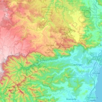
Name: Bellingen Shire Council topographic map, elevation, terrain.
Location: Bellingen Shire Council, New South Wales, Australia (-30.56707 152.38965 -30.18080 153.06064)
Average elevation: 480 m
Minimum elevation: -1 m
Maximum elevation: 1,536 m
Other topographic maps
Click on a map to view its topography, its elevation and its terrain.
Mount Gibraltar
Australia > New South Wales > Bowral
Mount Gibraltar (Aboriginal: Bowrell) is a mountain with an elevation of 863 metres (2,831 ft) AHD that is located in the Southern Highlands region, between Bowral and Mittagong, in New South Wales, Australia. Further west is Berrima.
Average elevation: 722 m
Prospect Hill
Australia > New South Wales > Sydney
As at 19 February 2001, the Prospect Hill area had state significance due to its unique combination of significant landscape feature, potential archaeological site, and association with important historical phases. As a dolerite outcrop rising to a height of 117 metres (384 ft) AHD , Prospect Hill is a rare…
Average elevation: 65 m
Sydney Observatory
Australia > New South Wales > Sydney
The place has an association with an extensive array of historical figures most of whom have helped shape its fabric. These include: colonial Governors Hunter, Bligh, Macquarie & Denison; military officers and engineers Macarthur; Barrallier; Bellasis and Minchin; convicts: the as yet unnamed constructors of…
Average elevation: 14 m
See Park
Australia > New South Wales > Broken Hill City Council > Broken Hill
Average elevation: 310 m
Mount Banda Banda
Nameplate at the summit of Mount Banda Banda, elevation 1258 metres
Average elevation: 907 m