
Make a donation
Gear up for your next adventure:
As an Amazon Associate, this site earns from qualifying purchases at no extra cost to you.
Lierneux topographic map
Click on the map to display elevation.
Make a donation
Gear up for your next adventure:
As an Amazon Associate, this site earns from qualifying purchases at no extra cost to you.
About this map
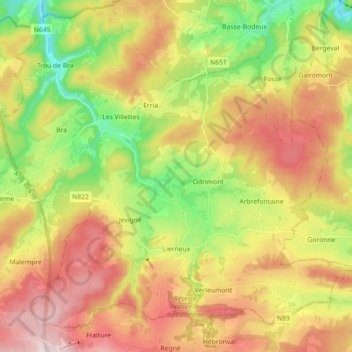
Name: Lierneux topographic map, elevation, terrain.
Location: Lierneux, Verviers, Liège, Wallonia, 4990, Belgium (50.25419 5.70282 50.36470 5.88138)
Average elevation: 445 m
Minimum elevation: 255 m
Maximum elevation: 650 m
Make a donation
Gear up for your next adventure:
As an Amazon Associate, this site earns from qualifying purchases at no extra cost to you.
Other topographic maps
Click on a map to view its topography, its elevation and its terrain.
Ardennes
Belgium > Liège > Verviers > Robertville
The region was uplifted by a mantle plume during the last few hundred thousand years, as measured from the present elevation of old river terraces.
Average elevation: 659 m
Make a donation
Gear up for your next adventure:
As an Amazon Associate, this site earns from qualifying purchases at no extra cost to you.
Ardennes
Belgium > Liège > Verviers > Robertville
The region the Ardennes are part of has been uplifted further in the last few hundred thousand years by a mantle plume, as measured from the present elevation of old river terraces, with the largest amount of uplift concentrated in the east, where the Ardennes connect with the Eifel, where the same mantle…
Average elevation: 659 m
Make a donation
Gear up for your next adventure:
As an Amazon Associate, this site earns from qualifying purchases at no extra cost to you.
Stavelot
Belgium > Liège > Verviers > Stavelot
Stavelot has an oceanic climate influenced by its high elevation and inland position towards a more continental type by Belgian standards. Being located at a lower elevation than neighbouring village Malmedy at the other end of the original layout of the Spa-Francorchamps race track, Stavelot is slightly…
Average elevation: 401 m
Make a donation
Gear up for your next adventure:
As an Amazon Associate, this site earns from qualifying purchases at no extra cost to you.
Make a donation
Gear up for your next adventure:
As an Amazon Associate, this site earns from qualifying purchases at no extra cost to you.
Make a donation
Gear up for your next adventure:
As an Amazon Associate, this site earns from qualifying purchases at no extra cost to you.
Make a donation
Gear up for your next adventure:
As an Amazon Associate, this site earns from qualifying purchases at no extra cost to you.
Make a donation
Gear up for your next adventure:
As an Amazon Associate, this site earns from qualifying purchases at no extra cost to you.
Make a donation
Gear up for your next adventure:
As an Amazon Associate, this site earns from qualifying purchases at no extra cost to you.
Make a donation
Gear up for your next adventure:
As an Amazon Associate, this site earns from qualifying purchases at no extra cost to you.
Signal de Botrange
Belgium > Liège > Verviers > Robertville
In 1923, the 6-metre (20-foot) Baltia tower was built on the summit to allow visitors to reach an altitude of 700 m (2,300 ft). A stone tower built in 1933/34 by François Fagnoul from Ovifat on the Botrange crowned a steel weather vane with the relieved name SICCO CAMPO until World War II. Meanwhile, the…
Average elevation: 658 m
Make a donation
Gear up for your next adventure:
As an Amazon Associate, this site earns from qualifying purchases at no extra cost to you.
Make a donation
Gear up for your next adventure:
As an Amazon Associate, this site earns from qualifying purchases at no extra cost to you.