Geolocate

Jihlava topographic map

Interactive map

Click on the map to display elevation.

About this map

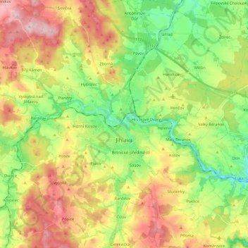
Name: Jihlava topographic map, elevation, terrain.

Location: Jihlava, okres Jihlava, Kraj Vysočina, Southeast, Czechia (49.33394 15.49831 49.47592 15.66235)

Average elevation: 553 m

Minimum elevation: 441 m

Maximum elevation: 700 m

Jihlava is located in the heart of the Bohemian-Moravian Highlands. The northern part of the territory lies in the Upper Sázava Hills, the southern part lies in the Křižanov Highlands. The highest point is the hill Popický vrch with an elevation of 682 metres (2,238 ft), located on the southern municipal border.

Wikipedia (CC-BY-SA 3.0)

Other topographic maps

Click on a map to view its topography, its elevation and its terrain.

Střítež

Czechia > Southeast > Kraj Vysočina

Střítež, okres Jihlava, Kraj Vysočina, Southeast, 588 11, Czechia

Average elevation: 496 m

Hrotovice

Czechia > Southeast > Kraj Vysočina

Hrotovice, okres Třebíč, Kraj Vysočina, Southeast, 675 55, Czechia

Average elevation: 412 m

Rybníček

Czechia > Southeast > Kraj Vysočina

Rybníček, okres Havlíčkův Brod, Kraj Vysočina, Southeast, Czechia

Average elevation: 484 m

Humpolec

Czechia > Southeast > Kraj Vysočina

Humpolec, okres Pelhřimov, Kraj Vysočina, Southeast, Czechia

Average elevation: 555 m

Řehořov

Czechia > Southeast > Kraj Vysočina

Řehořov, Kamenice, okres Jihlava, Kraj Vysočina, Southeast, 588 24, Czechia

Average elevation: 590 m

Stařeč

Czechia > Southeast > Kraj Vysočina > Stařeč

Stařeč, okres Třebíč, Kraj Vysočina, Southeast, 675 22, Czechia

Average elevation: 499 m

Kamenice

Czechia > Southeast > Kraj Vysočina > Kamenice > Kamenice

Kamenice, okres Jihlava, Kraj Vysočina, Southeast, 58823, Czechia

Average elevation: 567 m

Žďár nad Sázavou

Czechia > Southeast > Kraj Vysočina

Žďár nad Sázavou, okres Žďár nad Sázavou, Kraj Vysočina, Southeast, Czechia

Average elevation: 606 m

Ústí

Czechia > Southeast > Kraj Vysočina > Ústí > Ústí

Ústí, okres Jihlava, Kraj Vysočina, Southeast, 58842, Czechia

Average elevation: 610 m

Atmosférická stanice Košetice

Czechia > Southeast > Kraj Vysočina > Chýstovice

Atmosférická stanice Košetice, 112, Červův mlýn, Chýstovice, okres Pelhřimov, Kraj Vysočina, Southeast, 39422, Czechia

Average elevation: 522 m

Velké Meziříčí

Czechia > Southeast > Kraj Vysočina

Velké Meziříčí, okres Žďár nad Sázavou, Kraj Vysočina, Southeast, 594 01, Czechia

Average elevation: 523 m