
Humpolec topographic map
Interactive map
Click on the map to display elevation.
About this map
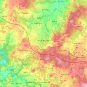
Name: Humpolec topographic map, elevation, terrain.
Location: Humpolec, okres Pelhřimov, Kraj Vysočina, Southeast, Czechia (49.48597 15.26176 49.59059 15.42387)
Average elevation: 555 m
Minimum elevation: 426 m
Maximum elevation: 683 m
Humpolec is located about 22 km (14 mi) northwest of Jindřichův Hradec, roughly halfway between Prague and Brno. It lies in the Křemešník Highlands. The hill Krásná vyhlídka with an altitude of 663 metres (2,175 ft) is the highest point of the municipal territory. There is a significant amount of small ponds, some of them are in the urban area.
Other topographic maps
Click on a map to view its topography, its elevation and its terrain.
Jihlava
Czechia > Southeast > Kraj Vysočina
Jihlava, okres Jihlava, Kraj Vysočina, Southeast, Czechia
Average elevation: 553 m
Střítež
Czechia > Southeast > Kraj Vysočina
Střítež, okres Jihlava, Kraj Vysočina, Southeast, 588 11, Czechia
Average elevation: 496 m
Hrotovice
Czechia > Southeast > Kraj Vysočina
Hrotovice, okres Třebíč, Kraj Vysočina, Southeast, 675 55, Czechia
Average elevation: 412 m
Rybníček
Czechia > Southeast > Kraj Vysočina
Rybníček, okres Havlíčkův Brod, Kraj Vysočina, Southeast, Czechia
Average elevation: 484 m
Řehořov
Czechia > Southeast > Kraj Vysočina
Řehořov, Kamenice, okres Jihlava, Kraj Vysočina, Southeast, 588 24, Czechia
Average elevation: 590 m
Stařeč
Czechia > Southeast > Kraj Vysočina > Stařeč
Stařeč, okres Třebíč, Kraj Vysočina, Southeast, 675 22, Czechia
Average elevation: 499 m
Žďár nad Sázavou
Czechia > Southeast > Kraj Vysočina
Žďár nad Sázavou, okres Žďár nad Sázavou, Kraj Vysočina, Southeast, Czechia
Average elevation: 606 m
Atmosférická stanice Košetice
Czechia > Southeast > Kraj Vysočina > Chýstovice
Atmosférická stanice Košetice, 112, Červův mlýn, Chýstovice, okres Pelhřimov, Kraj Vysočina, Southeast, 39422, Czechia
Average elevation: 522 m
Velké Meziříčí
Czechia > Southeast > Kraj Vysočina
Velké Meziříčí, okres Žďár nad Sázavou, Kraj Vysočina, Southeast, 594 01, Czechia
Average elevation: 523 m