
Long Island topographic map
Interactive map
Click on the map to display elevation.
Long Island
The land to the south of this moraine to the South Shore is the outwash plain of the last glacier. One part of the outwash plain was known as the Hempstead Plains, and this land contained one of the few natural prairies to exist east of the Appalachian Mountains. The glaciers melted and receded to the north, resulting in the difference between the topography of the North Shore beaches and the South Shore beaches. The North Shore beaches are rocky from the remaining glacial debris, while the South Shore's are crisp, clear, outwash sand. Jayne's Hill, at 401 feet (122 m), within Suffolk County near its border with Nassau County, is the highest hill along either moraine; another well-known summit is Bald Hill in Brookhaven Town, not far from its geographical center at Middle Island. The glaciers also formed Lake Ronkonkoma in Suffolk County and Lake Success in Nassau County, each a deep kettle lake.
About this map
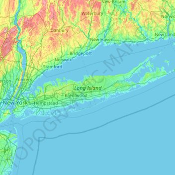
Name: Long Island topographic map, elevation, terrain.
Location: Long Island, New York, United States (40.54190 -74.04197 41.16116 -71.85627)
Average elevation: 42 m
Minimum elevation: -5 m
Maximum elevation: 498 m
Other topographic maps
Click on a map to view its topography, its elevation and its terrain.
New York
The city's land has been altered substantially by human intervention, with considerable land reclamation along the waterfronts since Dutch colonial times; reclamation is most prominent in Lower Manhattan, with developments such as Battery Park City in the 1970s and 1980s. Some of the natural relief in…
Average elevation: 19 m
Staten Island
United States > New York > New York
Although Staten Island is a borough of New York City, the island is topographically and geologically a part of New Jersey. Staten Island is separated from Long Island by the Narrows and from mainland New Jersey by the Arthur Kill and the Kill Van Kull. Staten Island is positioned at the center of New York…
Average elevation: 9 m
Buffalo
United States > New York > Erie County
The Buffalo metropolitan area is on the Erie/Ontario Lake Plain of the Eastern Great Lakes Lowlands, a narrow plain extending east to Utica, New York. The city is generally flat, except for elevation changes in the University Heights and Fruit Belt neighborhoods. The Southtowns are hillier, leading to the…
Average elevation: 185 m
Queens County
United States > New York > New York
Many of the village street grids of Queens had only worded names, some were numbered according to local numbering schemes, and some had a mix of words and numbers. In the early 1920s, a "Philadelphia Plan" was instituted to overlay one numbered system upon the whole borough. The Topographical Bureau, Borough…
Average elevation: 11 m
City of Albany
United States > New York > Albany County
The highest natural point in Albany is a USGS benchmark near the Loudonville Reservoir off Birch Hill Road, at 378 feet (115 m) above sea level. The lowest point is sea level at the Hudson River (the average water elevation is 2 feet (0.61 m)), which is still technically an estuary at Albany and is affected by…
Average elevation: 68 m
Hudson River
The Hudson then flows south, taking in Beaver Brook and the outlet of Lake Harris. After its confluence with the Indian River, the Hudson forms the boundary between Essex and Hamilton counties. In the hamlet of North River, the Hudson flows entirely in Warren County and takes in the Schroon River. Further…
Average elevation: 297 m
Chautauqua County
The county is generally composed of rolling hills and valleys, with elevations ranging anywhere between 1100 and 2100 feet, although the land within a few miles of Lake Erie is generally flat and at an elevation of 1000 feet or lower. The lowest point in the county is Lake Erie, at 571 feet (174 meters), and…
Average elevation: 328 m
Onondaga County
According to the U.S. Census Bureau, the county has an area of 806 square miles (2,090 km2), of which 778 square miles (2,020 km2) is land and 27 square miles (70 km2) (3.4%) is water. The geographic dimensions of the county are illustrated as approximately 35 miles (56 km) in length and 30 miles (48 km) in…
Average elevation: 233 m
Broome County
The county's western portion is hilly, with wide valleys that accommodate Binghamton and its suburbs. In the northern portion, Interstate 81 traverses a wide glacial valley. The eastern part of the county is much more rugged, as the land rises to the Catskill Mountains. The terrain generally slopes to the…
Average elevation: 413 m
Bronx County
United States > New York > New York
The Bronx's highest elevation at 280 feet (85 m) is in the northwest corner, west of Van Cortlandt Park and in the Chapel Farm area near the Riverdale Country School. The opposite (southeastern) side of the Bronx has four large low peninsulas or "necks" of low-lying land that jut into the waters of the East…
Average elevation: 21 m
Manhattan
United States > New York > New York County > New York
Marble Hill is one example of how Manhattan's land has been considerably altered by human intervention. The borough has seen substantial land reclamation along its waterfronts since Dutch colonial times, and much of the natural variation in its topography has been evened out.
Average elevation: 16 m
Central Park
United States > New York > New York County > New York
In June 1856, Fernando Wood appointed a "consulting board" of seven people, headed by author Washington Irving, to inspire public confidence in the proposed development. Wood hired military engineer Egbert Ludovicus Viele as the park's chief engineer, tasking him with a topographical survey of the site. The…
Average elevation: 26 m
City of Mount Vernon
United States > New York > Westchester County
Mount Vernon's elevation at City Hall is about 235 feet (72 m), reflecting its location between the Bronx River to the west and the Hutchinson River to the east. On a clear day, the Throgs Neck Bridge can be seen from 10 miles (20 km) away from many parts of the city, while at night, the bridge's lights can…
Average elevation: 42 m
Palisades
United States > New York > Rockland County > Sparkill
In 1800 the population of Palisades was 114. Because of the local topography the town was well suited to become a river center. Rising from the west bank of the Hudson River, the Palisades Cliff forms an obstacle to transport seeking access to the river. A break in the terrain occurs at Palisades, still known…
Average elevation: 29 m
Chautauqua Lake
United States > New York > Chautauqua County > Town of Chautauqua
Chautauqua Lake, at an elevation of 1,308 feet (399 m) above sea level, is higher than any of the Finger Lakes. It is also one of the highest navigable lakes in North America. The lake's water level is regulated by Warner Dam, with the water level lifted during the summer to allow for recreational boat use and…
Average elevation: 463 m
Central Islip
United States > New York > Suffolk County > Town of Islip > North Great River
Average elevation: 20 m
Town of Halcott
United States > New York > Greene County
The pass between Bearpen and neighboring Vly Mountain is traversed by Halcott Mountain Road, an unimproved county highway which reaches 2,800 feet (850 m) at the col, making it the highest elevation free public through road in New York State. It is also the only route between Halcott and the rest of Greene…
Average elevation: 720 m
Allegany County
Allegany County is in the southwestern part of New York State, along the Pennsylvania border. Allegany County does not lie along the Allegheny River, as its name would suggest. The highest point in the county is Alma Hill, with an elevation of 2,548 feet (777 meters) above sea level. This is the highest point…
Average elevation: 561 m
Kent Cliffs Unit
United States > New York > Putnam County > Town of Putnam Valley > Richardsville
Average elevation: 270 m
Fish Creek Pond
United States > New York > Franklin County > Town of Santa Clara
Average elevation: 491 m
Village of Newport
United States > New York > Herkimer County > Town of Newport
Average elevation: 235 m
Murdock Woods
United States > New York > Westchester County > Town of Mamaroneck
Average elevation: 46 m
Maple Mountain
United States > New York > Saint Lawrence County > Town of Fine
Average elevation: 476 m
Village of the Branch
United States > New York > Suffolk County > Town of Smithtown
Average elevation: 25 m
Turkey Mountain
United States > New York > Westchester County > Town of Yorktown
Average elevation: 142 m
Hartung-Boothroyd Observatory
United States > New York > Tompkins County > Town of Dryden > Varna
The primary 0.6m mirror was constructed from a Pyrex 1/8-scale test pouring as part of technology development for the Palomar Observatory 200-inch telescope. The mirror was polished and mounted in a lightweight tube in the late 1930s under Boothroyd's direction, but World War II deferred its planned use in a…
Average elevation: 477 m