
East Whitburn topographic map
Interactive map
Click on the map to display elevation.
About this map
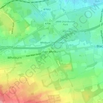
Name: East Whitburn topographic map, elevation, terrain.
Average elevation: 174 m
Minimum elevation: 138 m
Maximum elevation: 247 m
Other topographic maps
Click on a map to view its topography, its elevation and its terrain.
Bathgate
United Kingdom > Scotland > West Lothian
In the 1846 book A Topographical Dictionary of Scotland, Samuel Lewis writes.
Average elevation: 167 m
Linlithgow Palace and High Street Conservation Area
United Kingdom > Scotland > West Lothian > Linlithgow
Average elevation: 78 m
Armadale
United Kingdom > Scotland > West Lothian
Aside from the presence of the old castle, Armadale was little more than a rural farm community for most of its history, as part of a larger rural estate named Barbauchlaw (a corruption of 'Boar Baughlee'). However, this situation changed with the coming of the new turnpike road between Edinburgh and Glasgow…
Average elevation: 166 m