
Make a donation
Gear up for your next adventure:
As an Amazon Associate, this site earns from qualifying purchases at no extra cost to you.
Research Triangle topographic map
Click on the map to display elevation.
Make a donation
Gear up for your next adventure:
As an Amazon Associate, this site earns from qualifying purchases at no extra cost to you.
About this map
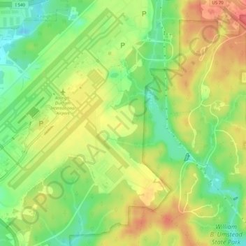
Name: Research Triangle topographic map, elevation, terrain.
Average elevation: 115 m
Minimum elevation: 6 m
Maximum elevation: 537 m
Make a donation
Gear up for your next adventure:
As an Amazon Associate, this site earns from qualifying purchases at no extra cost to you.
Other topographic maps
Click on a map to view its topography, its elevation and its terrain.
Asheville
United States > North Carolina > Buncombe County
Asheville, located in Buncombe County, North Carolina, is characterized by a diverse and picturesque topography primarily shaped by its position within the Blue Ridge Mountains. The city itself sits at an elevation of approximately 2,200 feet, surrounded by peaks that rise significantly higher, such as Mount…
Average elevation: 727 m
Charlotte
United States > North Carolina > Mecklenburg County
Charlotte, located in the Piedmont region of North Carolina, features a gently rolling terrain characterized by elevations ranging from approximately 650 to 700 feet (198 to 213 meters). The city is bordered to the west by the Catawba River, which contributes to the area's mild climate and lush vegetation.…
Average elevation: 207 m
Raleigh
United States > North Carolina > Wake County
Raleigh features a topography primarily defined by its position along the fall line, which is the geological boundary between the Piedmont and Coastal Plain regions. This area experiences a gradual elevation drop of approximately 150 to 350 feet over a distance of 1 to 3 miles as one moves eastward. The city's…
Average elevation: 103 m
Make a donation
Gear up for your next adventure:
As an Amazon Associate, this site earns from qualifying purchases at no extra cost to you.
Wilmington
United States > North Carolina > New Hanover County
Wilmington sits near the southeastern coast and has a low-lying, relatively flat topography with an average elevation around 36 feet above sea level. The terrain is characterized by coastal plains with minimal elevation changes, making the landscape generally flat as it gently slopes toward the Atlantic Ocean.…
Average elevation: 7 m
Charlotte
United States > North Carolina > Mecklenburg County
According to the United States Census Bureau, the city has a total area of 308.6 square miles (799 km2), of which 306.6 square miles (794 km2) is land and 2.0 square miles (5.2 km2) is water. Charlotte is the twenty-sixth-most expansive city in the United States and lies at an elevation of 751 feet (229 m).…
Average elevation: 207 m
Make a donation
Gear up for your next adventure:
As an Amazon Associate, this site earns from qualifying purchases at no extra cost to you.
Avery County
United States > North Carolina
Avery County showcases a strikingly rugged topography characterized by its placement within the Appalachian Mountains. This mountainous terrain features elevations averaging about 3,500 feet, making it one of the highest counties east of the Mississippi River. The highest peak in the county is Grassy Ridge…
Average elevation: 1,006 m
Boone
United States > North Carolina > Watauga County
Boone, located in Watauga County, North Carolina, is set within the rugged Appalachian Mountains, specifically the Blue Ridge range. With an elevation of approximately 3,300 feet (1,016 meters), it stands as one of the highest towns of its size in the eastern United States. The terrain is dominated by steep…
Average elevation: 1,069 m
Cashiers
United States > North Carolina > Jackson County > Cashiers
Cashiers lies in southern Jackson County on the elevated Highlands-Cashiers Plateau, a highland setting within the southern Blue Ridge Mountains, with the village center standing at about 3,500 feet (1,067 m) above sea level. Its topography is defined by a relatively open mountain basin surrounded by higher…
Average elevation: 1,085 m
Make a donation
Gear up for your next adventure:
As an Amazon Associate, this site earns from qualifying purchases at no extra cost to you.
Carolina Beach
United States > North Carolina > New Hanover County
Carolina Beach is characterized by its relatively flat topography, with elevations averaging around 13 feet above sea level. This coastal town is part of Pleasure Island and features a blend of sandy beaches and salt marshes. The surrounding area includes Carolina Beach State Park, which hosts diverse…
Average elevation: 2 m
Durham
United States > North Carolina > Durham County
Durham is located in the east-central part of the Piedmont region at 35°59′19″N 78°54′26″W / 35.98861°N 78.90722°W / 35.98861; -78.90722 (35.988644, −78.907167). Like much of the region, its topography is generally flat with some rolling hills.
Average elevation: 117 m
Make a donation
Gear up for your next adventure:
As an Amazon Associate, this site earns from qualifying purchases at no extra cost to you.
Hickory
United States > North Carolina > Catawba County
Lake Hickory was named after the City of Hickory and runs along its northern edge. The lake covers almost 4,223 acres (17.09 km2) with 105 miles (169 km) of shoreline. Full pond elevation is 935 feet (285 m). Lake Hickory is a reliable source of water for the Cities of Hickory and Conover and the Town of Long…
Average elevation: 317 m
Raleigh
United States > North Carolina > Wake County
Raleigh is located in the northeast central region of North Carolina, where the Piedmont and Atlantic coastal plain regions meet. This area is known as the "fall line" because it marks the elevation inland at which waterfalls begin to appear in creeks and rivers. As a result, most of Raleigh features gently…
Average elevation: 103 m
Make a donation
Gear up for your next adventure:
As an Amazon Associate, this site earns from qualifying purchases at no extra cost to you.
Ocean Isle Beach
United States > North Carolina > Brunswick County
Ocean Isle Beach is a picturesque barrier island characterized by its low-lying terrain and sandy shorelines. The topography features an average elevation of about 3 feet (1 meter) above sea level, with the landscape gently sloping towards the Atlantic Ocean. The island spans approximately 7 miles in length…
Average elevation: 4 m
Nash County
United States > North Carolina
Nash County rests in the northeastern part of North Carolina along the dividing line between the Peidmont and Coastal Plain regions. According to the U.S. Census Bureau, the county has a total area of 542.82 square miles (1,405.9 km2), of which 540.44 square miles (1,399.7 km2) is land and 2.38 square miles…
Average elevation: 59 m
Make a donation
Gear up for your next adventure:
As an Amazon Associate, this site earns from qualifying purchases at no extra cost to you.
Franklin
United States > North Carolina > Macon County
Franklin is characterized by its mountainous terrain, lying within the picturesque Appalachian Mountains. The area features rugged landscapes with elevations typically ranging from around 2,000 to 4,000 feet, creating dramatic vistas and deep valleys. The Little Tennessee River winds through the region, adding…
Average elevation: 675 m
West Jefferson
United States > North Carolina > Ashe County
West Jefferson is a popular destination among tourists and retirees from Florida, as well as those from the lower elevations of the Carolinas and Georgia.
Average elevation: 1,002 m
Make a donation
Gear up for your next adventure:
As an Amazon Associate, this site earns from qualifying purchases at no extra cost to you.
Alexander County
United States > North Carolina
Alexander County is located within the Foothills region of western North Carolina. The county's main geographic feature is the Brushy Mountains, a deeply eroded spur of the Blue Ridge Mountains to the west. The "Brushies," as they are called locally, rise from 300 to 1,000 feet (300 m) above the surrounding…
Average elevation: 364 m
Waynesville
United States > North Carolina > Haywood County
Most of the town of Waynesville lies between 2,600 and 3,000 feet (790 and 910 m) above sea level, in a valley among 5,000-to-6,410-foot (1,520 to 1,950 m) mountain peaks. With the high Great Balsam Mountains to the west-southwest, and the Plott Balsams to the west-northwest, a handful of peaks over 6000' in…
Average elevation: 921 m
Make a donation
Gear up for your next adventure:
As an Amazon Associate, this site earns from qualifying purchases at no extra cost to you.
Franklin County
United States > North Carolina
Franklin County exhibits a diverse topography characterized primarily by gently rolling hills and low-lying areas interspersed with valleys and water bodies. The county's elevation varies, with the highest points reaching approximately 600 feet above sea level, while much of the landscape sits around 300 to…
Average elevation: 92 m
Make a donation
Gear up for your next adventure:
As an Amazon Associate, this site earns from qualifying purchases at no extra cost to you.
Henderson County
United States > North Carolina
Due to its geographic setting along the Eastern Continental Divide and its extreme topographic variation, Henderson County presents a wide variation in temperature and precipitation conditions. The highest elevations occur along the northwest and northern boundaries of the county and within the Blue Ridge…
Average elevation: 703 m
Make a donation
Gear up for your next adventure:
As an Amazon Associate, this site earns from qualifying purchases at no extra cost to you.
New Bern
United States > North Carolina > Craven County
New Bern exhibits a predominantly flat terrain characterized by low-lying areas near its coastal rivers. The city is strategically positioned at the confluence of the Neuse and Trent rivers, where the elevation averages around 10 to 20 feet (3 to 6 meters) above sea level. This coastal setting contributes…
Average elevation: 5 m
Make a donation
Gear up for your next adventure:
As an Amazon Associate, this site earns from qualifying purchases at no extra cost to you.
Make a donation
Gear up for your next adventure:
As an Amazon Associate, this site earns from qualifying purchases at no extra cost to you.
Granville County
United States > North Carolina
Camp Butner, opened in 1942 as a training camp for World War II soldiers, once encompassed more than 40,000 acres in Granville, Person, and Durham counties. During the war, more than 30,000 soldiers were trained at Camp Butner, including the 35th and 89th divisions. The hilly topography at Camp Butner proved…
Average elevation: 133 m
Haywood County
United States > North Carolina
Haywood County is situated amidst the Blue Ridge Mountains and contains parts of several major subranges of the Blue Ridge, namely the Great Smoky Mountains in the west and the Plott Balsams and Great Balsam Mountains in the south. Notable peaks in the county include Cold Mountain, at 6,030 feet (1,840 m),…
Average elevation: 1,044 m
Make a donation
Gear up for your next adventure:
As an Amazon Associate, this site earns from qualifying purchases at no extra cost to you.
Forsyth County
United States > North Carolina
The northeast section of Forsyth County, including Belews Creek and parts of Rural Hall, Walkertown, and Kernersville, is drained by tributaries of the Dan River. A small portion of Kernersville is in the Cape Fear River basin. Most of the county is drained by tributaries of the Yadkin River, which forms the…
Average elevation: 258 m
Greensboro
United States > North Carolina > Guilford County
Greensboro is characterized by a gently rolling topography, typical of the Piedmont region. The city sits at an elevation of approximately 790 feet (241 meters) above sea level, with its terrain featuring a mix of low hills and valleys that create a varied landscape. The area is bisected by several waterways,…
Average elevation: 242 m
Make a donation
Gear up for your next adventure:
As an Amazon Associate, this site earns from qualifying purchases at no extra cost to you.
Blowing Rock
United States > North Carolina > Watauga County
Blowing Rock is characterized by its rugged and varied topography, nestled within the southern reaches of the Blue Ridge Mountains. The town itself is situated on a prominent ridge, with elevations ranging from approximately 3,300 to 3,600 feet, creating dramatic landscapes that feature steep slopes, rocky…
Average elevation: 1,032 m
Cherokee County
United States > North Carolina
Cherokee County is the westernmost county in the U.S. state of North Carolina. It borders Tennessee to its west and Georgia to its south. As of the 2010 census, the population was 27,444. The county seat is Murphy, population 1,627 (2010), elevation 1604 ft.
Average elevation: 655 m
Make a donation
Gear up for your next adventure:
As an Amazon Associate, this site earns from qualifying purchases at no extra cost to you.
Asheville
United States > North Carolina > Buncombe County
Asheville has a humid subtropical climate (Köppen Cfa), resembling the rest of the Piedmont region of the southeastern U.S., but with noticeably cooler temperatures due to the higher elevation; it is part of USDA Hardiness zone 7a. The area's summers in particular, though warm, are not as hot as summers in…
Average elevation: 727 m
Wilkes County
United States > North Carolina
Wilkes County is located on the eastern slope of the Blue Ridge Mountains, a part of the Appalachian Mountains chain. The county's elevation ranges from 900 feet (375 meters) in the east to over 4,000 feet (1,219 meters) in the west. The Blue Ridge Mountains run from the southwest to the northeast, and…
Average elevation: 513 m
Beech Mountain
United States > North Carolina > Watauga County
Beech Mountain is a town in both Avery and Watauga counties in the U.S. state of North Carolina. As of the 2010 census, the town population was 320. The town is located atop Beech Mountain and is the highest town east of the Rocky Mountains at 5,506 ft (1,678 m) in elevation. The nearest municipality at a…
Average elevation: 1,267 m
Make a donation
Gear up for your next adventure:
As an Amazon Associate, this site earns from qualifying purchases at no extra cost to you.
Macon County
United States > North Carolina
Cullasaja Falls is a waterfall in Southwestern North Carolina east of Franklin. The waterfall is located on the Cullasaja River in the Nantahala National Forest and is part of the Mountain Waters Scenic Byway. Cullasaja comes from a Cherokee word meaning "honey locust place." The falls is the last major…
Average elevation: 904 m
Sherrills Ford
United States > North Carolina > Catawba County
According to the United States Census Bureau, the CDP had a total area of 7.8 square miles (20 km2), 0.13% of which is water. It sits at an elevation of 204 m (670 ft).
Average elevation: 255 m
Make a donation
Gear up for your next adventure:
As an Amazon Associate, this site earns from qualifying purchases at no extra cost to you.
Cary
United States > North Carolina > Wake County
Cary is seated on the boundary between the Durham Basin with its softer sedimentary rocks and the piedmont with its harder metamorphic rocks; both geologic provinces have igneous rock intrusions. The landscape is typically gentle to moderate sloping hills separated by narrow V-shaped valleys, but there are…
Average elevation: 111 m
Mars Hill
United States > North Carolina > Madison County
According to the United States Census Bureau, the town has a total area of 1.9 square miles (4.9 km2), all land. The town has an elevation of 2,330 feet (710 m), so the climate of the area is considerably cooler than might be expected of a town in a southern state.
Average elevation: 708 m
Make a donation
Gear up for your next adventure:
As an Amazon Associate, this site earns from qualifying purchases at no extra cost to you.
Make a donation
Gear up for your next adventure:
As an Amazon Associate, this site earns from qualifying purchases at no extra cost to you.
Haywood County
United States > North Carolina
Haywood County is situated amidst the Blue Ridge Mountains and contains parts of several major subranges of the Blue Ridge, namely the Great Smoky Mountains in the west and the Plott Balsams and Great Balsam Mountains in the south. Notable peaks in the county include Cold Mountain, at 6,030 feet (1,840 m),…
Average elevation: 1,044 m
Make a donation
Gear up for your next adventure:
As an Amazon Associate, this site earns from qualifying purchases at no extra cost to you.
Polk County
United States > North Carolina
The elevation in the county ranges from just under 800 feet (240 m) near the confluence of the Green River and Broad River to over 3,200 feet (980 m) on Tryon Peak and Wildcat Spur, the highest peak in the county. Polk County is divided into two physiographic regions; the Blue Ridge Mountains in the western…
Average elevation: 414 m
Murphy
United States > North Carolina > Cherokee County
Murphy has a humid subtropical climate, (Cfa) according to the Köppen classification, with hot, humid summers and cool to mild winters, with low temperatures significantly cooler than other parts of the Southeast, due in part to the elevation. Like the rest of the southeastern U.S., Murphy receives abundant…
Average elevation: 514 m
Fuquay-Varina
United States > North Carolina > Wake County
Fuquay-Varina is located in the northeast central region of North Carolina, where the North American Piedmont and Atlantic Coastal Plain regions meet. This area is known as the "Fall Line" because it marks the elevation inland at which waterfalls begin to appear in creeks and rivers. Its central Piedmont…
Average elevation: 113 m
Make a donation
Gear up for your next adventure:
As an Amazon Associate, this site earns from qualifying purchases at no extra cost to you.
Nantahala National Forest
United States > North Carolina > Macon County
The terrain varies in elevation from 5,800 feet (1,767.8 m) at Lone Bald in Jackson County, to 1,200 feet (365.8 m) in Cherokee County along the Hiwassee River below the Appalachia Dam. It is the home of many western NC waterfalls. The last part of the Mountain Waters Scenic Byway travels through this forest.…
Average elevation: 781 m
Wayne County
United States > North Carolina
Wayne County's surface is level to gently rolling uplands with broad bottoms along the rivers and some creeks. Elevations are predominantly 120 to 145 feet above sea level. The largest waterway, the Neuse River, bisects the lower central portion of the county and cuts a deep channel 20 to 40 feet deep as it…
Average elevation: 39 m
Knightdale
United States > North Carolina > Wake County
Knightdale is located in the northeast central region of North Carolina, where the North American Piedmont and Atlantic Coastal Plain regions meet. This area is known as the "Fall Line" because it marks the elevation inland at which waterfalls begin to appear in creeks and rivers. Its central Piedmont location…
Average elevation: 84 m
Make a donation
Gear up for your next adventure:
As an Amazon Associate, this site earns from qualifying purchases at no extra cost to you.
Make a donation
Gear up for your next adventure:
As an Amazon Associate, this site earns from qualifying purchases at no extra cost to you.
Make a donation
Gear up for your next adventure:
As an Amazon Associate, this site earns from qualifying purchases at no extra cost to you.
Davidson County
United States > North Carolina
Davidson County is located entirely within the Piedmont region of central North Carolina. The Piedmont consists of gently rolling terrain frequently broken by hills or shallow valleys formed by rivers and streams. An exception to this terrain are the Uwharrie Mountains in the county's western and southwestern…
Average elevation: 222 m
Banner Elk
United States > North Carolina > Avery County
Banner Elk is nestled within the Blue Ridge Mountains, characterized by rugged and varied terrain. The town itself sits at an elevation of around 3,700 feet, offering expansive views of the surrounding peaks and valleys. This region, part of the southern Appalachian range, includes steep slopes, dense forests,…
Average elevation: 1,165 m
Make a donation
Gear up for your next adventure:
As an Amazon Associate, this site earns from qualifying purchases at no extra cost to you.