
Dhading Besi topographic map
Interactive map
Click on the map to display elevation.
About this map
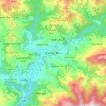
Name: Dhading Besi topographic map, elevation, terrain.
Location: Dhading Besi, Nilakantha, Dhading, Bagmati Pradesh, Nepal (27.87089 84.85528 27.95089 84.93528)
Average elevation: 873 m
Minimum elevation: 493 m
Maximum elevation: 1,589 m
It is at 27°54'45.9"N 84°53'46.2"E at an altitude of 612 metres.[1]
Other topographic maps
Click on a map to view its topography, its elevation and its terrain.
Sarketari Baandh/ Risk And Hazards/ Flood
Nepal > Dhading > Dhading Besi
Sarketari Baandh/ Risk And Hazards/ Flood, Nilkantha Municipality Ward No. 4, Dhading Besi, Nilakantha, Dhading, Bagmati Pradesh, Nepal
Average elevation: 933 m