Geolocate

Husö topographic map

Click on the map to display elevation.

About this map

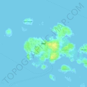
Name: Husö topographic map, elevation, terrain.

Location: Husö, Sottunga, Ålands Archipelago, Åland Islands, Finland (60.06465 20.78984 60.07778 20.82209)

Average elevation: 1 m

Minimum elevation: -1 m

Maximum elevation: 19 m

Other topographic maps

Click on a map to view its topography, its elevation and its terrain.

Orrdalsklint

Finland > Åland Islands

Average elevation: 57 m

Torsholma

Finland > Åland Islands > Brändö

Average elevation: 2 m

Hammarland

Finland > Åland Islands

Average elevation: 3 m

Kumlinge

Finland > Åland Islands

Average elevation: 2 m

Gear up for your next adventure:

🧥Waterproof Hiking Jackets - Rain protection for walking in all weather conditions
📦Compression Sacks - Reduce backpack volume efficiently
🥾Walking Shoes - Lightweight walking shoes for countryside and coastal paths
🥾Men's Waterproof Hiking Boots - Durable footwear with deep lugs for muddy and rocky UK terrains
🛌Sleeping Mats - Insulated mats for comfortable outdoor sleeping

As an Amazon Associate, this site earns from qualifying purchases at no extra cost to you.