
Make a donation
Gear up for your next adventure:
As an Amazon Associate, this site earns from qualifying purchases at no extra cost to you.
Gomirje topographic map
Click on the map to display elevation.
Make a donation
Gear up for your next adventure:
As an Amazon Associate, this site earns from qualifying purchases at no extra cost to you.
About this map
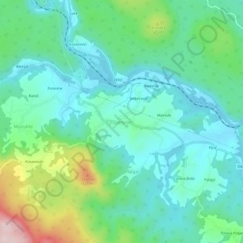
Name: Gomirje topographic map, elevation, terrain.
Average elevation: 431 m
Minimum elevation: 338 m
Maximum elevation: 712 m
Make a donation
Gear up for your next adventure:
As an Amazon Associate, this site earns from qualifying purchases at no extra cost to you.
Other topographic maps
Click on a map to view its topography, its elevation and its terrain.
Krk
Croatia > Primorje-Gorski Kotar County
A Eurasian griffon vulture colony lives in protected in an area called Kuntrep on Krk., There they breed at low elevations, with some nests at 10 m (33 ft). Therefore, contact with people is common.
Average elevation: 95 m
Mali Lošinj
Croatia > Primorje-Gorski Kotar County
Since records began in 1961, the highest temperature recorded at the local weather station at an elevation of 53 metres (174 ft) was 39.0 °C (102.2 °F), on 6 August 2017. From 1981 to 2011, the highest temperature recorded at the Čikat weather station was 36.6 °C (97.9 °F), on 2 August 1998. The coldest…
Average elevation: 9 m
Make a donation
Gear up for your next adventure:
As an Amazon Associate, this site earns from qualifying purchases at no extra cost to you.
Begovo Razdolje
Croatia > Primorje-Gorski Kotar County
Begovo Razdolje (Croatian pronunciation: [bɛ̂ɡɔʋɔ rǎːzdɔːʎɛ]) is a village in Mrkopalj municipality, Primorje-Gorski Kotar County, in western Croatia. At 1,060 m (3,478 ft), it is the settlement with the highest elevation in Croatia.
Average elevation: 1,072 m
Make a donation
Gear up for your next adventure:
As an Amazon Associate, this site earns from qualifying purchases at no extra cost to you.
Make a donation
Gear up for your next adventure:
As an Amazon Associate, this site earns from qualifying purchases at no extra cost to you.
Make a donation
Gear up for your next adventure:
As an Amazon Associate, this site earns from qualifying purchases at no extra cost to you.
Lošinj
Croatia > Primorje-Gorski Kotar County > Veli Lošinj
Lošinj is part of the Cres-Lošinj archipelago. The Cres-Lošinj archipelago includes the two major islands Cres and Lošinj, some minor islands Unije, Ilovik, Susak, Vele Srakane, Male Srakane and a number of uninhabited small islets and outcrops. Cres is the largest by area, followed by Lošinj. Cres and…
Average elevation: 14 m
Susak
Croatia > Primorje-Gorski Kotar County > Susak
Located in the Kvarner Bay and southeast of the Istrian peninsula, the Croatian island of Susak is 7.4 kilometers (4.6 mi; 4.0 nmi) southwest from the island of Lošinj, 10 kilometers (6.2 mi; 5.4 nmi) south of the island of Unije, and 120 kilometers (75 mi; 65 nmi) east of the Italian coast. Susak is about 3…
Average elevation: 13 m
Make a donation
Gear up for your next adventure:
As an Amazon Associate, this site earns from qualifying purchases at no extra cost to you.
Grad Rijeka
Croatia > Primorje-Gorski Kotar County
Since records began in 1948, the highest temperature recorded at the local weather station at an elevation of 120 metres (390 ft) was 40.0 °C (104.0 °F), on 19 July 2007. The coldest temperature was −12.8 °C (9.0 °F), on 10 February 1956.
Average elevation: 209 m
Make a donation
Gear up for your next adventure:
As an Amazon Associate, this site earns from qualifying purchases at no extra cost to you.
Make a donation
Gear up for your next adventure:
As an Amazon Associate, this site earns from qualifying purchases at no extra cost to you.
Make a donation
Gear up for your next adventure:
As an Amazon Associate, this site earns from qualifying purchases at no extra cost to you.
Općina Mrkopalj
Croatia > Primorje-Gorski Kotar County
A weather station exists there at an elevation of 825 metres (2,707 ft), although under a shelter that compromises the applicability to surroundings. The minimum recorded temperature for the winter of 2024–2025 was −16.2 °C (2.8 °F), on February 20.
Average elevation: 1,010 m
Make a donation
Gear up for your next adventure:
As an Amazon Associate, this site earns from qualifying purchases at no extra cost to you.
Make a donation
Gear up for your next adventure:
As an Amazon Associate, this site earns from qualifying purchases at no extra cost to you.
Make a donation
Gear up for your next adventure:
As an Amazon Associate, this site earns from qualifying purchases at no extra cost to you.
Make a donation
Gear up for your next adventure:
As an Amazon Associate, this site earns from qualifying purchases at no extra cost to you.
Krk
Croatia > Primorje-Gorski Kotar County
The island forms part of the Kvarner Islands Important Bird Area (IBA), designated as such by BirdLife International because it supports significant numbers of many bird species, including breeding populations of several birds of prey. A Eurasian griffon vulture colony lives in a protected area called Kuntrep.…
Average elevation: 95 m