
Mitunguu topographic map
Interactive map
Click on the map to display elevation.
About this map
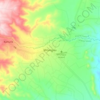
Name: Mitunguu topographic map, elevation, terrain.
Location: Mitunguu, Imenti South, Meru County, Eastern, Kenya (-0.14839 37.74083 -0.06839 37.82083)
Average elevation: 1,006 m
Minimum elevation: 854 m
Maximum elevation: 1,239 m
Other topographic maps
Click on a map to view its topography, its elevation and its terrain.
Igoji
Kenya > Meru County > Imenti South
Igoji, Imenti South, Meru County, Eastern, Kenya
Average elevation: 1,309 m
Baranga
Kenya > Meru County > Imenti South
Baranga, Imenti South, Meru County, Eastern, Kenya
Average elevation: 1,346 m
Nkubu
Kenya > Meru County > Imenti South
Nkubu, Imenti South, Meru County, Eastern, Kenya
Average elevation: 1,487 m