
Make a donation
Gear up for your next adventure:
As an Amazon Associate, this site earns from qualifying purchases at no extra cost to you.
Mount Erciyes topographic map
Click on the map to display elevation.
Make a donation
Gear up for your next adventure:
As an Amazon Associate, this site earns from qualifying purchases at no extra cost to you.
Mount Erciyes
The climate of the region is influenced by topography, with the Taurus and Kaçkar Mountains blocking the entry of moisture into Anatolia. Summers are dry and hot and winters wet and cold; in Kayseri, summer temperatures are about 19 °C (66 °F) and winter temperature about 0 °C (32 °F). Precipitation at Kayseri falls mostly in autumn, winter, and spring and amounts to 383 millimetres (15.1 in) per year. In Develi, south of Erciyes, maximum temperatures are about 29.5 °C (85.1 °F) and minimum temperatures −5.6 °C (21.9 °F). Estimated temperatures at 2,700 metres (8,900 ft) altitude are about −0.4 °C (31.3 °F), and precipitation 722 millimetres (28.4 in) per year. During the last glacial maximum, precipitation may have been double that of present-day.
Make a donation
Gear up for your next adventure:
As an Amazon Associate, this site earns from qualifying purchases at no extra cost to you.
About this map
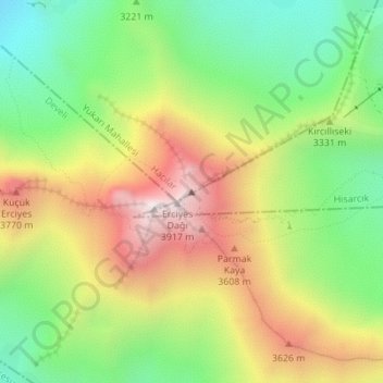
Name: Mount Erciyes topographic map, elevation, terrain.
Location: Mount Erciyes, Hacılar, Central Anatolia Region, Turkey (38.53269 35.45017 38.53279 35.45027)
Average elevation: 3,329 m
Minimum elevation: 2,878 m
Maximum elevation: 3,896 m
Make a donation
Gear up for your next adventure:
As an Amazon Associate, this site earns from qualifying purchases at no extra cost to you.