Geolocate

Batchingou topographic map

Click on the map to display elevation.

About this map

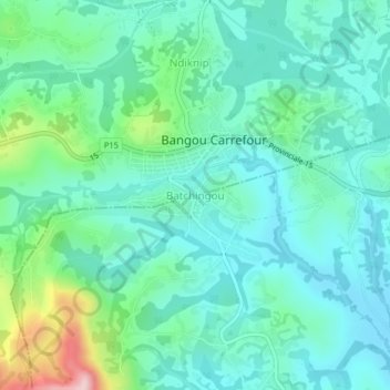
Name: Batchingou topographic map, elevation, terrain.

Location: Batchingou, Bangangté, Ndé, West, Cameroon (5.15290 10.36193 5.19290 10.40193)

Average elevation: 1,436 m

Minimum elevation: 1,372 m

Maximum elevation: 1,666 m

Other topographic maps

Click on a map to view its topography, its elevation and its terrain.

Ngou

Cameroon > West > Ndé > Bangangté

Average elevation: 869 m

Gear up for your next adventure:

🔥Reusable Hand Warmers - Maintain dexterity in your fingers for precise map handling
🌄Compact Monoculars - Lightweight optics for hiking
🧤Hiking Gloves - Warm and durable gloves for cold-weather walks
🔪Outdoor Multi-Tools - Versatile tools for gear repairs and food prep in the wild
👖Packable Overtrousers - Quick-deploy rain protection for legs in sudden storms

As an Amazon Associate, this site earns from qualifying purchases at no extra cost to you.