
Planajeur topographic map
Interactive map
Click on the map to display elevation.
About this map
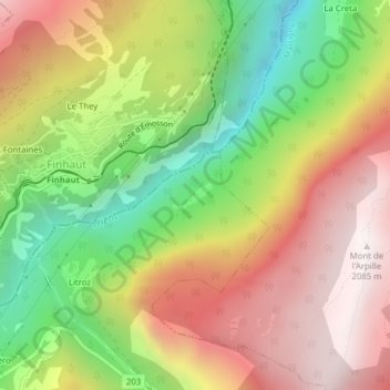
Name: Planajeur topographic map, elevation, terrain.
Location: Planajeur, Trient, Martigny, Valais, 1929, Suisse (46.07064 6.97939 46.09064 6.99939)
Average elevation: 1,429 m
Minimum elevation: 746 m
Maximum elevation: 2,074 m
Other topographic maps
Click on a map to view its topography, its elevation and its terrain.
Croix de Fer
Croix de Fer, Trient, Martigny, Valais, 1929, Suisse
Average elevation: 1,971 m
Gite d'etape du Peuty (Dortoir Peuty)
Gite d'etape du Peuty (Dortoir Peuty), Le Peuty, Trient, Martigny, Valais, 1929, Suisse
Average elevation: 1,711 m