
Carpathian Mountains topographic map
Interactive map
Click on the map to display elevation.
About this map
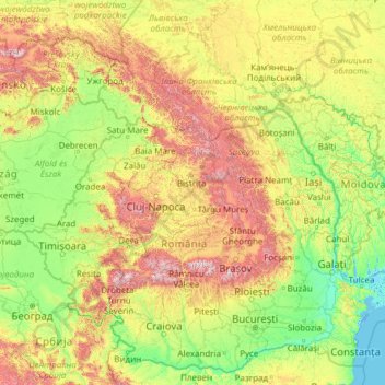
Name: Carpathian Mountains topographic map, elevation, terrain.
Location: Carpathian Mountains, Romania (43.39906 16.07849 50.06100 27.16369)
Average elevation: 330 m
Minimum elevation: -3 m
Maximum elevation: 2,432 m
The northwestern Carpathians begin in Slovakia and southern Poland. They surround Transcarpathia and Transylvania in a large semicircle, sweeping towards the southeast, and end on the Danube near Orșova in Romania. The total length of the Carpathians is over 1,500 km (930 mi). The mountain chain's width varies between 12 and 500 km (7 and 311 mi). The highest altitudes of the Carpathians occur where they are widest. The system attains its greatest breadth in the Transylvanian plateau and in the southern Tatra Mountains group – the highest range, in which Gerlachovský štít in Slovakia is the highest peak, is 2,655 m (8,711 ft) above sea level. The Carpathians cover an area of 190,000 km2 (73,000 sq mi). After the Alps, they form the next-most extensive mountain system in Europe.
Other topographic maps
Click on a map to view its topography, its elevation and its terrain.
Peana
Romania > Cluj > Cluj-Napoca
Peana, Cluj-Napoca, Cluj Metropolitan Area, Cluj, 407271, Romania
Average elevation: 741 m
Mărtinești
Mărtinești, Tureni, Cluj Metropolitan Area, Cluj, 407563, Romania
Average elevation: 585 m
Dorolea
Dorolea, Livezile, Bistrița-Năsăud, 427122, Romania
Average elevation: 488 m
Carpathian Mountains
Carpathian Mountains, Toplița, Harghita, 535705, Romania
Average elevation: 980 m