
临桂区 topographic map
Interactive map
Click on the map to display elevation.
About this map
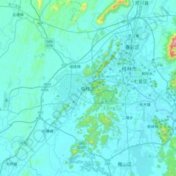
Name: 临桂区 topographic map, elevation, terrain.
Location: 临桂区, 桂林市, 广西壮族自治区, 中国 (25.08188 110.04776 25.40188 110.36776)
Average elevation: 182 m
Minimum elevation: 137 m
Maximum elevation: 860 m
Other topographic maps
Click on a map to view its topography, its elevation and its terrain.