
Kenai Peninsula Borough topographic map
Interactive map
Click on the map to display elevation.
About this map
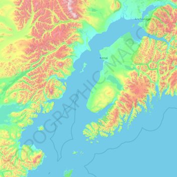
Name: Kenai Peninsula Borough topographic map, elevation, terrain.
Location: Kenai Peninsula Borough, Alaska, United States (58.64501 -154.74877 61.42816 -148.56303)
Average elevation: 370 m
Minimum elevation: -1 m
Maximum elevation: 3,351 m
Other topographic maps
Click on a map to view its topography, its elevation and its terrain.
Denali
United States > Alaska > Denali Borough
Denali (/dəˈnɑːli/), federally designated as Mount McKinley, is the highest mountain peak in North America, with a summit elevation of 20,310 feet (6,190 m) above sea level. It is the tallest mountain in the world from base to peak on land, measuring 18,000 ft (5,500 m). With a topographic prominence of…
Average elevation: 5,546 m
Mount Fairweather
United States > Alaska > Yakutat
Mount Fairweather (or Tsalxaan in the Tlingit language) is a mountain located 20 km (12 mi) east of the Pacific Ocean on the Canada–United States border. With an elevation of 4,653 metres (15,266 ft), it is the tallest mountain in British Columbia and the seventh-tallest mountain in both Alaska and the…
Average elevation: 3,845 m
Denali
United States > Alaska > Denali Borough
Denali (/dəˈnɑːli/), federally designated as Mount McKinley, is the highest mountain peak in North America, with a summit elevation of 20,310 feet (6,190 m) above sea level. It is the tallest mountain in the world from base to peak on land, measuring 18,000 ft (5,500 m). With a topographic prominence of…
Average elevation: 5,546 m
Toolik Lake
United States > Alaska > North Slope Borough
Tussock tundra dominates the terrain surrounding the lake. Other plant communities in the area include wet sedge tundra, as well drier heath tundra found at higher elevations. Low growing shrubs are abundant, including birches and willows. Trees are not present. Since surveys began, there has been a 19 percent…
Average elevation: 731 m
Chatanika
United States > Alaska > Fairbanks North Star Borough
Located 2 miles (3.2 km) east of the confluence of Cleary Creek and the Chatanika River, Chatanika lies 20 miles (32 km) northeast of Fairbanks. Its altitude is 896 feet (273 m).
Average elevation: 272 m
Mount Katmai
United States > Alaska > Kodiak Island Borough
Mount Katmai (Russian: Катмай) is a large active stratovolcano (composite volcano) on the Alaska Peninsula in southern Alaska, located within Katmai National Park and Preserve. It is about 6.3 miles (10 km) in diameter with a central lake-filled caldera about two by three miles (3.2 by 4.8 km) in size,…
Average elevation: 1,515 m
Kasatochi Island
United States > Alaska > Unorganized Borough
Kasatochi Island is a member of the Aleutian Islands, which lie above a narrow ridge that separates the Bering Sea from the North Pacific. It lies at the Atka Pass northwest of the western tip of Atka Island and east of Great Sitkin Island. It is at 52.177° N latitude and 175.508° W longitude, with a summit…
Average elevation: 53 m
Mount Katmai
United States > Alaska > Kodiak Island Borough
Mount Katmai (Russian: Катмай) is a large active stratovolcano (composite volcano) on the Alaska Peninsula in southern Alaska, located within Katmai National Park and Preserve. It is about 6.3 miles (10 km) in diameter with a central lake-filled caldera about two by three miles (3.2 by 4.8 km) in size,…
Average elevation: 1,515 m
Denali
United States > Alaska > Denali Borough
Denali (/dəˈnɑːli/), federally designated as Mount McKinley, is the highest mountain peak in North America, with a summit elevation of 20,310 feet (6,190 m) above sea level. It is the tallest mountain in the world from base-to-peak on land, measuring 18,000 ft (5,500 m). With a topographic prominence of…
Average elevation: 5,546 m
Eagle Summit
United States > Alaska > Unorganized Borough
It was for this latter reason that engineers chose Eagle Summit as the route to build the Steese Highway, which connects Fairbanks, Alaska to the Yukon River at Circle. In 1927, just 11 years after Stuck became one of the first Americans to navigate Eagle Summit on dog sled, the highway was completed and road…
Average elevation: 1,068 m
Carlisle Island
United States > Alaska > Aleutians West Census Area
Despite its modest summit elevation, a small glacier exists high on the western slopes just below the rim of the summit crater.
Average elevation: 217 m
Homer
United States > Alaska > Kenai Peninsula
Many of the birds seen during the festival can be identified with the help of published guides that categorize distinguishable features such as, topography, silhouette, size, and color.
Average elevation: 104 m
Homer
United States > Alaska > Kenai Peninsula > Homer
Some birds seen during the spring migration and the festival include horned puffins, sandhill cranes, and arctic terns. Arctic Terns are famous for flying the longest distance of any migrating bird. Many of the birds seen during the festival can be identified with the help of published guides that categorize…
Average elevation: 106 m
Denali
United States > Alaska > Denali Borough
Denali (/dəˈnɑːli/; also known as Mount McKinley, its former official name) is the highest mountain peak in North America, with a summit elevation of 20,310 feet (6,190 m) above sea level. With a topographic prominence of 20,194 feet (6,155 m) and a topographic isolation of 4,621.1 miles (7,436.9 km),…
Average elevation: 5,546 m