
Lake Ontario topographic map
Interactive map
Click on the map to display elevation.
About this map
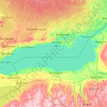
Name: Lake Ontario topographic map, elevation, terrain.
Location: Lake Ontario, Ontario, Canada (43.15936 -79.92529 44.29337 -76.04535)
Average elevation: 214 m
Minimum elevation: 70 m
Maximum elevation: 699 m
Lake Ontario is the easternmost of the Great Lakes and the smallest in surface area (7,340 sq mi, 18,960 km2), although it exceeds Lake Erie in volume (393 cu mi, 1,639 km3). It is the 13th largest lake in the world. When its islands are included, the lake's shoreline is 712 miles (1,146 km) long. As the last lake in the Great Lakes' hydrologic chain, Lake Ontario has the lowest mean surface elevation of the lakes at 243 feet (74 m) above sea level; 326 feet (99 m) lower than its neighbor upstream. Its maximum length is 193 statute miles (311 kilometres; 168 nautical miles) and its maximum width is 53 statute miles (85 km; 46 nmi). The lake's average depth is 47 fathoms 1 foot (283 ft; 86 m), with a maximum depth of 133 fathoms 4 feet (802 ft; 244 m). The lake's primary source is the Niagara River, draining Lake Erie, with the St. Lawrence River serving as the outlet. The drainage basin covers 24,720 square miles (64,030 km2). As with all the Great Lakes, water levels change both within the year (owing to seasonal changes in water input) and among years (owing to longer term trends in precipitation). These water level fluctuations are an integral part of lake ecology, and produce and maintain extensive wetlands. The lake also has an important freshwater fishery, although it has been negatively affected by factors including over-fishing, water pollution and invasive species.
Other topographic maps
Click on a map to view its topography, its elevation and its terrain.
Thunder Bay
Canada > Ontario > Thunder Bay District
Thunder Bay, Thunder Bay District, Northwestern Ontario, Ontario, Canada
Average elevation: 240 m
Admaston/Bromley
Canada > Ontario > Renfrew County
Admaston/Bromley, Renfrew County, Eastern Ontario, Ontario, Canada
Average elevation: 180 m
The Blue Mountains
Canada > Ontario > Grey County
The Blue Mountains, Grey County, Ontario, N0H 2P0, Canada
Average elevation: 265 m
Peterborough
Canada > Ontario > Peterborough
Peterborough, Central Ontario, Ontario, K9H 7E8, Canada
Average elevation: 235 m
Ferris Provincial Park
Canada > Ontario > Northumberland County > Trent Hills > Campbellford
Ferris Provincial Park, Campbellford, Trent Hills, Northumberland County, Central Ontario, Ontario, Canada
Average elevation: 151 m
Milton
Canada > Ontario > Halton Region
Milton, Halton Region, Golden Horseshoe, Ontario, Canada
Average elevation: 237 m
Kakagi Lake
Canada > Ontario > Kenora District > Unorganized Kenora District
Kakagi Lake, Unorganized Kenora District, Kenora District, Northwestern Ontario, Ontario, Canada
Average elevation: 368 m
Old Toronto
Old Toronto, Toronto, Golden Horseshoe, Ontario, Canada
Average elevation: 116 m
Highlands East
Canada > Ontario > Haliburton County
Highlands East, Haliburton County, Central Ontario, Ontario, Canada
Average elevation: 381 m
Moose Creek
Canada > Ontario > Stormont, Dundas and Glengarry Counties > North Stormont
Moose Creek, North Stormont, Stormont, Dundas and Glengarry Counties, Eastern Ontario, Ontario, K0C 1W0, Canada
Average elevation: 87 m
Thessalon
Canada > Ontario > Algoma District
Thessalon, Algoma District, Northeastern Ontario, Ontario, Canada
Average elevation: 180 m
Lasswade Lake
Canada > Ontario > Peterborough County > North Kawartha
Lasswade Lake, North Kawartha, Peterborough County, Central Ontario, Ontario, Canada
Average elevation: 329 m
Greenstone
Canada > Ontario > Thunder Bay District
Greenstone, Thunder Bay District, Northwestern Ontario, Ontario, Canada
Average elevation: 351 m
Lake Temiskaming
Canada > Ontario > Timiskaming District > Unorganized West Timiskaming
Lake Temiskaming, Unorganized West Timiskaming, Duhamel-Ouest, Timiskaming District, Northeastern Ontario, Ontario, Canada
Average elevation: 279 m
Mississippi Mills
Canada > Ontario > Lanark County
Mississippi Mills, Lanark County, Eastern Ontario, Ontario, Canada
Average elevation: 148 m
Mattawa
Canada > Ontario > Nipissing District
Mattawa, Nipissing District, Northeastern Ontario, Ontario, Canada
Average elevation: 192 m
Brampton
Canada > Ontario > Peel Region
Brampton, Peel Region, Golden Horseshoe, Ontario, Canada
Average elevation: 223 m
Welland
Canada > Ontario > Niagara Region
Welland, Niagara Region, Golden Horseshoe, Ontario, Canada
Average elevation: 182 m
Red Rock
Canada > Ontario > Thunder Bay District > Red Rock Township
Red Rock, Red Rock Township, Thunder Bay District, Northwestern Ontario, Ontario, P0T 2P0, Canada
Average elevation: 218 m
Emsdale
Canada > Ontario > Parry Sound District > Perry Township
Emsdale, Perry Township, Parry Sound District, Central Ontario, Ontario, P0A 1J0, Canada
Average elevation: 349 m
Blytheswood
Canada > Ontario > Essex County > Leamington
Blytheswood, Leamington, Essex County, Ontario, N8H 3V6, Canada
Average elevation: 194 m
Grimsby
Canada > Ontario > Niagara Region
Grimsby, Niagara Region, Golden Horseshoe, Ontario, Canada
Average elevation: 127 m
Northumberland
Northumberland, Central Ontario, Ontario, K0K 2H0, Canada
Average elevation: 164 m
Oakland
Canada > Ontario > Essex County > Leamington
Oakland, Leamington, Essex County, Ontario, N0P 2J0, Canada
Average elevation: 191 m
Thornbury
Canada > Ontario > Grey County
Thornbury, The Blue Mountains, Grey County, Ontario, N0H 2P0, Canada
Average elevation: 202 m
Kapuskasing
Canada > Ontario > Cochrane District
Kapuskasing, Cochrane District, Northeastern Ontario, Ontario, Canada
Average elevation: 227 m
Latchford
Canada > Ontario > Timiskaming District
Latchford, Timiskaming District, Northeastern Ontario, Ontario, P0J 1N0, Canada
Average elevation: 346 m
Calabogie Lake
Canada > Ontario > Renfrew County > Greater Madawaska > Calabogie
Calabogie Lake, Calabogie, Greater Madawaska, Renfrew County, Eastern Ontario, Ontario, Canada
Average elevation: 181 m
St. Joseph Island
Canada > Ontario > Algoma District > Jocelyn Township
St. Joseph Island, Jocelyn Township, Algoma District, Northeastern Ontario, Ontario, Canada
Average elevation: 196 m
McLaren Island
Canada > Ontario > Stormont, Dundas and Glengarry Counties > South Stormont > Ingleside
McLaren Island, Ingleside, South Stormont, Stormont, Dundas and Glengarry Counties, Eastern Ontario, Ontario, Canada
Average elevation: 74 m
Picton
Canada > Ontario > Prince Edward County
Picton, Prince Edward County, Central Ontario, Ontario, M4N 1A5, Canada
Average elevation: 112 m
North Oshawa Park
Canada > Ontario > Durham Region > Oshawa
North Oshawa Park, Oshawa, Durham Region, Golden Horseshoe, Ontario, Canada
Average elevation: 140 m
Colgan
Canada > Ontario > Simcoe County > Adjala–Tosorontio
Colgan, Adjala–Tosorontio, Simcoe County, Central Ontario, Ontario, L0G 1W0, Canada
Average elevation: 261 m
Ruthven
Canada > Ontario > Essex County > Kingsville
Ruthven, Kingsville, Essex County, Ontario, N0P 2G0, Canada
Average elevation: 202 m
Atikokan
Canada > Ontario > Rainy River District
Atikokan, Rainy River District, Northwestern Ontario, Ontario, Canada
Average elevation: 422 m
Benton Green
Canada > Ontario > Region of Waterloo > Kitchener
Benton Green, Victoria Park Heritage District, Kitchener, Region of Waterloo, Ontario, Canada
Average elevation: 334 m
Killarney Provincial Park
Canada > Ontario > Sudbury District > Killarney
Killarney Provincial Park, 960, Highway 637, Killarney, Sudbury District, Northeastern Ontario, Ontario, P0M 2A0, Canada
Average elevation: 225 m
Private Thomas Millar Armstrong Park
Canada > Ontario > York Region > Richmond Hill
Private Thomas Millar Armstrong Park, Richmond Hill, York Region, Golden Horseshoe, Ontario, Canada
Average elevation: 202 m
Greater Sudbury
Canada > Ontario > Sudbury District
Greater Sudbury, Sudbury District, Northeastern Ontario, Ontario, Canada
Average elevation: 305 m
Oxford
Canada > Ontario > Oxford County > South-West Oxford
Oxford, South-West Oxford, Oxford County, Ontario, Canada
Average elevation: 297 m
New Lowell
Canada > Ontario > Simcoe County > Clearview
New Lowell, Clearview, Simcoe County, Central Ontario, Ontario, L0M 1N0, Canada
Average elevation: 210 m
Augusta
Canada > Ontario > Leeds and Grenville Counties
Augusta, Leeds and Grenville Counties, Eastern Ontario, Ontario, Canada
Average elevation: 103 m
Stoney Creek
Canada > Ontario > Thunder Bay District > Unorganized Thunder Bay District
Stoney Creek, Unorganized Thunder Bay District, Thunder Bay District, Northwestern Ontario, Ontario, Canada
Average elevation: 367 m
William (Bill) Hill Promenade
Canada > Ontario > Halton Region > Oakville
William (Bill) Hill Promenade, Bronte Village, Bronte, Oakville, Halton Region, Golden Horseshoe, Ontario, L6L 1C5, Canada
Average elevation: 80 m
Crete Island
Canada > Ontario > Muskoka District > Muskoka Lakes Township
Crete Island, Muskoka Lakes Township, District Municipality of Muskoka, Muskoka District, Central Ontario, Ontario, Canada
Average elevation: 228 m