
Lake Ontario topographic map
Interactive map
Click on the map to display elevation.
Lake Ontario
Lake Ontario is the easternmost of the Great Lakes and the smallest in surface area (7,340 sq mi, 18,960 km2), although it exceeds Lake Erie in volume (393 cu mi, 1,639 km3). It is the 13th largest lake in the world. When its islands are included, the lake's shoreline is 712 miles (1,146 km) long. As the last lake in the Great Lakes' hydrologic chain, Lake Ontario has the lowest mean surface elevation of the lakes at 243 feet (74 m) above sea level; 326 feet (99 m) lower than its neighbor upstream. Its maximum length is 193 statute miles (311 kilometres; 168 nautical miles) and its maximum width is 53 statute miles (85 km; 46 nmi). The lake's average depth is 47 fathoms 1 foot (283 ft; 86 m), with a maximum depth of 133 fathoms 4 feet (802 ft; 244 m). The lake's primary source is the Niagara River, draining Lake Erie, with the St. Lawrence River serving as the outlet. The drainage basin covers 24,720 square miles (64,030 km2). As with all the Great Lakes, water levels change both within the year (owing to seasonal changes in water input) and among years (owing to longer term trends in precipitation). These water level fluctuations are an integral part of lake ecology, and produce and maintain extensive wetlands. The lake also has an important freshwater fishery, although it has been negatively affected by factors including over-fishing, water pollution and invasive species.
About this map
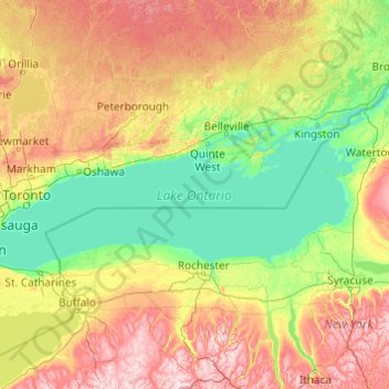
Name: Lake Ontario topographic map, elevation, terrain.
Location: Lake Ontario, Ontario, Canada (43.15936 -79.92529 44.29337 -76.04535)
Average elevation: 214 m
Minimum elevation: 70 m
Maximum elevation: 699 m
Other topographic maps
Click on a map to view its topography, its elevation and its terrain.
Peterborough
Canada > Ontario > Peterborough
Peterborough's topography is largely defined by land formations created by the receding Wisconsian glaciers 10,000–15,000 years ago. The South End and Downtown portions of the City sit on what was the bottom of the glacial Lake Peterborough—part of a glacial spillway created when glacial meltwaters from…
Average elevation: 235 m
Black Bass Island
Canada > Ontario > Parry Sound District > The Archipelago Township
Average elevation: 202 m
Shetland Island
Canada > Ontario > Leeds and Grenville Counties > Leeds and the Thousand Islands
Average elevation: 74 m
Lady Evelyn Lake
Canada > Ontario > Timiskaming District > Unorganized West Timiskaming
Average elevation: 318 m
Albany Island
Canada > Ontario > Cochrane District > Unorganized North Cochrane
Average elevation: 12 m
Kashabowie
Canada > Ontario > Thunder Bay District > Unorganized Thunder Bay District
Average elevation: 467 m
Alexandria
Canada > Ontario > Stormont, Dundas and Glengarry Counties > North Glengarry
Average elevation: 84 m
Old Toronto
Despite its deep ravines, Toronto is not remarkably hilly, but its elevation does increase steadily away from the lake. Elevation differences range from 76.5 metres (251 ft) above sea level at the Lake Ontario shore to 209 m (686 ft) above sea level near the York University grounds in the city's north end at…
Average elevation: 116 m
St. Catharines
Canada > Ontario > Niagara Region
The most defining transportation icon of St. Catharines is the Welland Canal, a ship canal that runs 43.4 kilometres (27.0 mi), passing through the city. Four of its locks are within city boundaries. The canal allows shipping vessels to traverse the 99.5-metre (326.5 ft) drop in altitude from Lake Erie to Lake…
Average elevation: 103 m
Mount Arabella
Canada > Ontario > Sudbury District > Unorganized North Sudbury
Average elevation: 243 m
Quabbin
Canada > Ontario > Leeds and Grenville Counties > Leeds and the Thousand Islands
Average elevation: 97 m
Sarnia
Canada > Ontario > Lambton County
Sarnia is located on the eastern shore of Lake Huron at its extreme southern point, where it flows into the St. Clair River. Most of the surrounding area is flat, and the elevation ranges from 169 to 281 m (554 to 922 ft) above sea level. The soil mainly comprises clay. Despite this high percentage of clay,…
Average elevation: 186 m
Ludgate
Canada > Ontario > Parry Sound District > Unorganized Centre Parry Sound
Average elevation: 194 m
Baltics Corners
Canada > Ontario > Stormont, Dundas and Glengarry Counties > North Glengarry
Average elevation: 95 m
Central Ontario
Along the northern edge of Central Ontario, are some of the highest elevations in Southern Ontario. These highlands are known as the Opeongo Hills, and they stretch into portions of Eastern Ontario as well.
Average elevation: 255 m
Beausoleil Island
Canada > Ontario > Muskoka District > Georgian Bay Township
Average elevation: 180 m
Wasaga Beach
Canada > Ontario > Simcoe County
The Town of Wasaga Beach covers an area of 61.13 square kilometres (23.60 sq mi) composed predominantly of sand and loamy sand that exhibit excessive to good drainage and irregular to moderately sloping topography. The poor soil quality makes it difficult to sustain lush lawns in the town. The Canada Land…
Average elevation: 190 m
Hamilton
Hamilton's climate is humid-continental, characterized by changeable weather patterns. In the Köppen classification, Hamilton it is on the Dfb/Dfa border found in southern Ontario because the average temperature in July is 22.0 °C (71.6 °F). However, its climate is moderate compared with most of Canada. The…
Average elevation: 187 m
Mountain Peak
Canada > Ontario > Timiskaming District > Unorganized West Timiskaming
Average elevation: 255 m
Dalkeith
Canada > Ontario > Stormont, Dundas and Glengarry Counties > North Glengarry
Average elevation: 70 m
Bronson Lake;Vermilion River
Canada > Ontario > Sudbury District > Greater Sudbury
Average elevation: 345 m
Ferris Provincial Park
Canada > Ontario > Northumberland County > Trent Hills > Campbellford
Average elevation: 151 m
Lake Temiskaming
Canada > Ontario > Timiskaming District > Unorganized West Timiskaming
Average elevation: 279 m
Christian Island
Canada > Ontario > Simcoe County
Christian Island is a large island in Georgian Bay close to the communities of Penetanguishene and Midland, Ontario. The island, with its neighbours Hope Island and Beckwith Island, is a 5,428.1 hectares (13,413.1 acres) Ojibwa reserve, known as Christian Island Indian Reserve No. 30. Together with the 7.5…
Average elevation: 185 m