Geolocate

Kagbeni topographic map

Interactive map

Click on the map to display elevation.

About this map

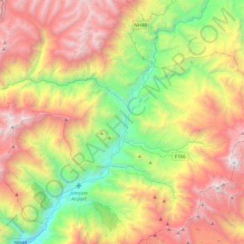
Name: Kagbeni topographic map, elevation, terrain.

Location: Kagbeni, Barhagaun Muktikhsetra, Mustang, Gandaki Pradesh, Nepal (28.78913 83.47900 28.92751 83.82212)

Average elevation: 5,013 m

Minimum elevation: 2,584 m

Maximum elevation: 7,180 m

Other topographic maps

Click on a map to view its topography, its elevation and its terrain.

Lo Manthang

Nepal > Mustang > Lomanthang

Lo Manthang, Lomanthang, Mustang, Gandaki Pradesh, Nepal

Average elevation: 4,899 m

Chhairo

Nepal > Mustang > Marpha

Chhairo, Marpha, Gharapjhong, Mustang, Gandaki Pradesh, Nepal

Average elevation: 3,105 m

Muktinath

Nepal > Mustang

Muktinath, Barhagaun Muktikhsetra, Mustang, Gandaki Pradesh, Nepal

Average elevation: 4,668 m

Titi lake

Nepal > Mustang > Kunjo > Titi Tal

Titi lake, Titi Tal, Kunjo, Thasang, Mustang, Gandaki Pradesh, Nepal

Average elevation: 2,809 m