
Union Canal topographic map
Interactive map
Click on the map to display elevation.
About this map
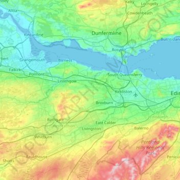
Name: Union Canal topographic map, elevation, terrain.
Location: Union Canal, Falkirk, Scotland, EH11 1HL, United Kingdom (55.91628 -3.84183 56.00172 -3.20805)
Average elevation: 136 m
Minimum elevation: -3 m
Maximum elevation: 564 m
Canal commences from the sixteenth lock of the Forth and Clyde Navigation, about two miles west of Falkirk, in the county of Sterling , whence it takes an eastwardly course on the south side of the above-mentioned town, by some collieries; thence, through Black Hill Tunnel, and across the Glen Water, on which stream, at a short distance to the southward, is constructed a considerable reservoir. Its line hence is by Brighton Freestone Quarries, and about a mile north from Park Hill Colliery, to the Avon River, over which there is an aqueduct conveying the canal at an elevation of 80 feet above the surface of the river. The canal here enters the county of Linlithgow, and passes within a mile and a half on the south side of its capital, to Craighton House, where its course is more southerly and circuitous, to the River Almond, near Clifton House, where it crosses into Edinburghshire, by means of an aqueduct. Its course hence is by Ratho House, and across Leith River, to the city of Edinburgh, where it terminates by a basin at the Lothian Road, about half a mile south-west of the castle. The length of the canal is thirty miles , the depth of water 5 feet , and is on one level from Edinburgh to its western extremity, where it falls 110 feet , in one series of locks, into the Forth and Clyde Canal.
Other topographic maps
Click on a map to view its topography, its elevation and its terrain.
Falkirk
United Kingdom > Scotland > Falkirk
Falkirk, Scotland, FK1 1ED, United Kingdom
Average elevation: 69 m
Reddingmuirhead
United Kingdom > Scotland > Falkirk
Reddingmuirhead, Falkirk, Scotland, FK2 0GS, United Kingdom
Average elevation: 102 m
Bonnybridge
United Kingdom > Scotland > Falkirk
Bonnybridge, Falkirk, Scotland, FK4 1BX, United Kingdom
Average elevation: 84 m
Airth
United Kingdom > Scotland > Falkirk
Airth, Falkirk, Scotland, FK2 8JN, United Kingdom
Average elevation: 8 m
California
United Kingdom > Scotland > Falkirk
California, Falkirk, Scotland, FK1 2DA, United Kingdom
Average elevation: 159 m
Maddiston
United Kingdom > Scotland > Falkirk
Maddiston, Falkirk, Scotland, FK2 0LQ, United Kingdom
Average elevation: 106 m
Torwood
United Kingdom > Scotland > Falkirk
Torwood, Falkirk, Scotland, FK5 4TB, United Kingdom
Average elevation: 50 m
Bo'ness
United Kingdom > Scotland > Falkirk
Bo'ness, Falkirk, Scotland, EH51 9AB, United Kingdom
Average elevation: 29 m
Brightons
United Kingdom > Scotland > Falkirk
Brightons, Falkirk, Scotland, FK2 0JT, United Kingdom
Average elevation: 89 m
Denny
United Kingdom > Scotland > Falkirk
Denny, Falkirk, Scotland, FK6 6EL, United Kingdom
Average elevation: 86 m
Wallacestone
United Kingdom > Scotland > Falkirk > Wallacestone
Wallacestone, Falkirk, Scotland, FK2 0DJ, United Kingdom
Average elevation: 119 m
South Alloa
United Kingdom > Scotland > Falkirk > South Alloa
South Alloa, Falkirk, Scotland, FK7 7LB, United Kingdom
Average elevation: 8 m
Grangemouth
United Kingdom > Scotland > Falkirk
Grangemouth, Falkirk, Scotland, FK3 8BG, United Kingdom
Average elevation: 19 m
Polmont
United Kingdom > Scotland > Falkirk
Polmont, Falkirk, Scotland, FK2 0PX, United Kingdom
Average elevation: 65 m
Rumford
United Kingdom > Scotland > Falkirk > Rumford
Rumford, Falkirk, Scotland, FK2 0SD, United Kingdom
Average elevation: 104 m
Shieldhill
United Kingdom > Scotland > Falkirk
Shieldhill, Falkirk, Scotland, FK1 2DX, United Kingdom
Average elevation: 147 m
Larbert
United Kingdom > Scotland > Falkirk
Larbert, Falkirk, Scotland, FK5 4AL, United Kingdom
Average elevation: 43 m
Limerigg
United Kingdom > Scotland > Falkirk
Limerigg, Falkirk, Scotland, FK1 3BP, United Kingdom
Average elevation: 205 m
Slamannan
United Kingdom > Scotland > Falkirk
Slamannan, Falkirk, Scotland, FK1 3EH, United Kingdom
Average elevation: 178 m
Carron
United Kingdom > Scotland > Falkirk > Carron
Carron, Falkirk, Scotland, FK2 8DS, United Kingdom
Average elevation: 16 m
Banknock
United Kingdom > Scotland > Falkirk
Banknock, Falkirk, Scotland, FK4 1HX, United Kingdom
Average elevation: 93 m
Avonbridge
United Kingdom > Scotland > Falkirk
Avonbridge, Falkirk, Scotland, FK1 2NG, United Kingdom
Average elevation: 169 m
Stenhousemuir
United Kingdom > Scotland > Falkirk
Stenhousemuir, Falkirk, Scotland, FK5 4HD, United Kingdom
Average elevation: 34 m
Laurieston
United Kingdom > Scotland > Falkirk
Laurieston, Falkirk, Scotland, FK2 9PS, United Kingdom
Average elevation: 44 m
Fankerton
United Kingdom > Scotland > Falkirk > Denny
Fankerton, Denny, Falkirk, Scotland, FK6 5HZ, United Kingdom
Average elevation: 121 m