Geolocate

Guruve topographic map

Interactive map

Click on the map to display elevation.

About this map

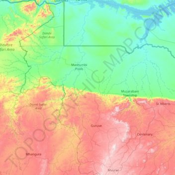
Name: Guruve topographic map, elevation, terrain.

Location: Guruve, Mashonaland Central Province, Zimbabwe (-17.06530 30.04074 -15.62092 31.14623)

Average elevation: 765 m

Minimum elevation: 314 m

Maximum elevation: 1,731 m

Other topographic maps

Click on a map to view its topography, its elevation and its terrain.

Lions Head

Zimbabwe > Mashonaland Central Province > Shamva

Lions Head, Shamva, Mashonaland Central Province, Zimbabwe

Average elevation: 1,203 m

Breacon Dam

Zimbabwe > Mashonaland Central Province > Bindura > Mazowe

Breacon Dam, Mazowe, Bindura, Mashonaland Central Province, Zimbabwe

Average elevation: 1,254 m

Gena

Zimbabwe > Mashonaland Central Province > Bindura

Gena, Bindura, Mashonaland Central Province, Zimbabwe

Average elevation: 1,327 m

Bindura

Zimbabwe > Mashonaland Central Province > Bindura

Bindura, Mashonaland Central Province, Zimbabwe

Average elevation: 1,089 m

Mazowe River

Zimbabwe > Mashonaland Central Province > Mazowe

Mazowe River, Mazowe, Mashonaland Central Province, Zimbabwe

Average elevation: 1,261 m