
Province of Tarma topographic map
Interactive map
Click on the map to display elevation.
About this map
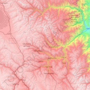
Name: Province of Tarma topographic map, elevation, terrain.
Location: Province of Tarma, Junín, 12651, Peru (-11.60114 -75.97208 -10.90030 -75.40195)
Average elevation: 3,783 m
Minimum elevation: 854 m
Maximum elevation: 5,014 m
Other topographic maps
Click on a map to view its topography, its elevation and its terrain.
San Juan de Jarpa
San Juan de Jarpa, Province of Chupaca, Junín, Peru
Average elevation: 4,110 m
San Lorenzo
Peru > Junín > San Lorenzo
San Lorenzo, Province of Jauja, Junín, Peru
Average elevation: 3,452 m
Concepción
Peru > Junín > Concepción
Concepción, Province of Concepción, Junín, 12125, Peru
Average elevation: 3,344 m
Ciudad Satélite
Peru > Junín > Ciudad Satélite
Ciudad Satélite, Province of Satipo, Junín, Peru
Average elevation: 768 m