
Surcin Urban Municipality topographic map
Interactive map
Click on the map to display elevation.
About this map
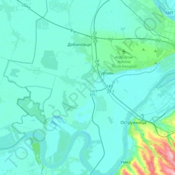
Name: Surcin Urban Municipality topographic map, elevation, terrain.
Average elevation: 84 m
Minimum elevation: 67 m
Maximum elevation: 243 m
Other topographic maps
Click on a map to view its topography, its elevation and its terrain.
Begaljica
Serbia > Central Serbia > City of Belgrade > Grocka Urban Municipality
The village is located at the water source of the Begaljica river. The houses are located in the valley sides and flat areas nearer the river, while a large part is located on the hill as well. The highest elevations are at Gornji Kraj and Brđani. The atar (cadastral area) is large, while half of it is…
Average elevation: 182 m
Dren
Serbia > Central Serbia > City of Belgrade > Obrenovac Urban Municipality
Average elevation: 98 m
Velika Mostanica
Serbia > Central Serbia > City of Belgrade > Cukarica Urban Municipality
Average elevation: 174 m
Tresnja
Serbia > Central Serbia > City of Belgrade > Sopot Urban Municipality
Average elevation: 255 m
Usce
Serbia > Central Serbia > City of Belgrade > Obrenovac Urban Municipality
Average elevation: 80 m
Mala Ivanca
Serbia > Central Serbia > City of Belgrade > Sopot Urban Municipality
Average elevation: 204 m
Рипањска капија
Serbia > Central Serbia > City of Belgrade > Sopot Urban Municipality
Average elevation: 245 m
Jagnjilo
Serbia > Central Serbia > City of Belgrade > Mladenovac Urban Municipality > Jagnjilo
Average elevation: 155 m
Колубара
Serbia > Central Serbia > City of Belgrade > Lazarevac Urban Municipality
Average elevation: 108 m
Младеновац (село)
Serbia > Central Serbia > City of Belgrade > Mladenovac Urban Municipality
Average elevation: 206 m