
Ploiești topographic map
Interactive map
Click on the map to display elevation.
About this map
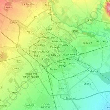
Name: Ploiești topographic map, elevation, terrain.
Location: Ploiești, Prahova, Romania (44.89614 25.91790 44.96842 26.10197)
Average elevation: 158 m
Minimum elevation: 105 m
Maximum elevation: 264 m
The city lies on the Wallachian Plain, having an average altitude of 150 m (490 ft). The surrounding landscape is influenced by its position around the Prahova River, whose stream bed lies 25 km (16 mi) to the west. The Teleajen River passes through the city while the Dâmbu River passes through the north-eastern neighbourhoods.
Other topographic maps
Click on a map to view its topography, its elevation and its terrain.
Valea Călugărească
Romania > Prahova > Valea Călugărească
Valea Călugărească, Prahova, Romania
Average elevation: 154 m
Chiojdeanca
Romania > Prahova > Chiojdeanca
Chiojdeanca, Prahova, 107150, Romania
Average elevation: 321 m
Iordăcheanu
Romania > Prahova > Iordăcheanu
Iordăcheanu, Prahova, 107310, Romania
Average elevation: 194 m