
Make a donation
Gear up for your next adventure:
As an Amazon Associate, this site earns from qualifying purchases at no extra cost to you.
Acatlán topographic map
Click on the map to display elevation.
Make a donation
Gear up for your next adventure:
As an Amazon Associate, this site earns from qualifying purchases at no extra cost to you.
Acatlán
As the municipal seat, the town of Acatlán is the governing authority for about sixty five other communities (INEGI) which cover an area of 174.70 km2. However, as of 2005, only 418 out of the total municipal population of 17914 lives in the town proper (INEGI). The municipality borders the municipalities of Huasca de Ocampo, Agua Blanca de Iturbide, Metepec, Tulancingo de Bravo and Singuilucan. The town and municipality are located in the Tulancingo Valley. Notable elevations include the Cerro la Providencia and Cerro Prieto. Other elevations are located near the municipality's borders with Huasca and Tulancingo. It is located in the Moctezuma River basin with rivers and streams such as the Grande Tulancingo, Los Enlamaderos, Las Vegas, El Meco and Salto de Alcholoya. Depending on elevation, the climate ranges from temperate and semi-arid (70% of the territory) to temperate and semi-humid, with rains mostly in the summer and early autumn. Average annual temperature is 14 °C. Most of the vegetation is adapted to dry conditions and includes grasses, cactus, palm trees and mesquites. In higher elevations, some broadleaf trees can be found. Wildlife mostly consists of small mammals such as squirrels, opossums, foxes and others. Bird species include eagles, owls and buzzards and reptiles include rattlesnakes and chameleons.
Make a donation
Gear up for your next adventure:
As an Amazon Associate, this site earns from qualifying purchases at no extra cost to you.
About this map
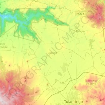
Name: Acatlán topographic map, elevation, terrain.
Location: Acatlán, Hidalgo, Mexico (20.07478 -98.51728 20.33507 -98.36445)
Average elevation: 2,195 m
Minimum elevation: 1,513 m
Maximum elevation: 3,172 m
Make a donation
Gear up for your next adventure:
As an Amazon Associate, this site earns from qualifying purchases at no extra cost to you.
Other topographic maps
Click on a map to view its topography, its elevation and its terrain.
Make a donation
Gear up for your next adventure:
As an Amazon Associate, this site earns from qualifying purchases at no extra cost to you.
Make a donation
Gear up for your next adventure:
As an Amazon Associate, this site earns from qualifying purchases at no extra cost to you.
Make a donation
Gear up for your next adventure:
As an Amazon Associate, this site earns from qualifying purchases at no extra cost to you.
Make a donation
Gear up for your next adventure:
As an Amazon Associate, this site earns from qualifying purchases at no extra cost to you.
Make a donation
Gear up for your next adventure:
As an Amazon Associate, this site earns from qualifying purchases at no extra cost to you.